

Five miles, Tuesday November 10th 2015, 2:00pm–4:00pm, five miles starting from the High Trees car park (by the roundabout where the A2037 joins the A283). Organized by Horsham District Council, free, led by trained volunteers. No need to book, just turn-up at start point.
Category: Truleigh Hill
Truleigh Hill Health Walk
Five miles, Tuesday July 14th 2015, 2:00pm–4:00pm, five miles starting from the High Trees car park (by the roundabout where the A2037 joins the A283). Organized by Horsham District Council, free, led by trained volunteers. No need to book, just turn-up at start point.
Truleigh Hill Health Walk
Five miles, Tuesday June 9th 2015, 2:00pm–4:00pm, five miles starting from the High Trees car park (by the roundabout where the A2037 joins the A283). Organized by Horsham District Council, free, led by trained volunteers. No need to book, just turn-up at start point.
Truleigh Hill Health Walk
Five miles, Tuesday October 14th 2014, 2:00pm–4:00pm, five miles starting from the High Trees car park (by the roundabout where the A2037 joins the A283). Organized by Horsham District Council, free, led by trained volunteers. No need to book, just turn-up at start point.
Truleigh Hill Health Walk
Five miles, Tuesday September 9th 2014, 2:00pm–4:00pm, starting from the High Trees car park (by the roundabout where the A2037 joins the A283). Organized by Horsham District Council, free, led by trained volunteers. No need to book, just turn-up at start point.
Organized mountain bike rides
A sermon on Tottington Mount

Readers of the Yr Arolygiaeth Gynllunio report [PDF] cannot help but notice that the inspectors were much exercised by Tottington Mount. It is discussed or referenced on no fewer than 32 pages. By contrast, there isn’t a single reference to Truleigh Hill anywhere.
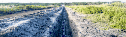
Tottington Mount lies between the Truleigh Hill Youth Hostel and Tottington Manor Farm. There is a public footpath opposite the farm that will take you up and across the mount. It is extremely steep for much of the route. Apart from the splendid view to the north, there’s not much to see. You will pass a long low earthwork as you near the summit. The mount itself just looks like canonical downland to an inexpert eye. As the map above indicates, the trench will bisect the mount.
Tottington Mount is a virgin patch of Downs that has never been ploughed. As a consequence, it hosts noteworthy plant species (page 57). The works area for the trench is to narrow from 30-40 metres to 20-30 metres as it cuts across the area (page 94). E.ON will be spending £330K on bog matting and other mitigation expenses on this small section of the trench (page 38). Some details of the mitigation plans, and the SDNPA’s scepticism about them, can be found on pages 57-58. The inspectors think that these mitigation efforts may well fail (page 41). The trench will skirt the Beeding Hill to Newtimber Hill SSSI (Site of Special Scientific Interest) with a margin of about 50 yards at Tottington Mount. Disturbance to the chalk grassland species living within the SSSI will be ‘negligible’, apparently. Indeed, these species are set to benefit significantly from all the environmental monitoring that will be happening at Tottington Mount as part of the mitigation exercise (pages 52-53). However, Adonis Blue caterpillars may not share this upbeat view — they risk losing their lunch (pages 67-68).
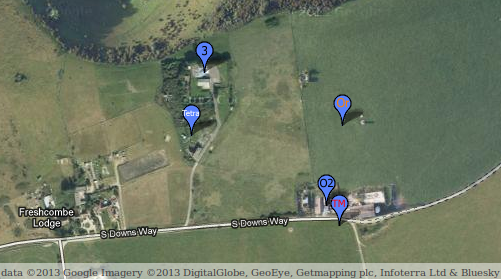
The earthwork is a Bronze Age cross dyke and is listed as an ancient monument. The trench will go right through it (click the map above to see the detail of this), something that English Heritage refers to as a “substantial harmful effect” (page 178). The good news is that archaeologists will be funded to root around in the rubble — “appropriate archaeological supervision” (page 179, pages 398-399) — and English Heritage felt able to rule that “the harm is necessary in order to deliver substantial public benefits that outweigh the harm” (page 178). In turn, the inspectors concluded that there will be “be no loss of significance of any designated or undesignated heritage asset” (page 182) notwithstanding the “risk of adverse effects upon heritage assets, including the Tottington Mount Scheduled Ancient Monument” (page 227).
Minister approved trench today
The West Sussex County Times reports:
Onshore construction is expected to start in 2015 and the project including the offshore installation will take four years to complete.
The Argus adds:
For the wind farm to go ahead the company will need to make a final investment decision on the project, and apply for subsidies.
You will surely also want to read the 590-page report from Yr Arolygiaeth Gynllunio: Rampion Offshore Wind Farm and connection works — Examining Authority’s Report of Findings and Conclusions and Recommendation to the Secretary of State for Energy and Climate Change [PDF].
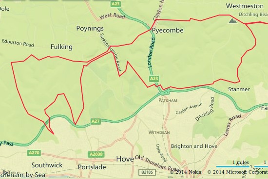
The route of the envisaged trench through Edburton is shown here.
Mobile promises
The Argus reports:
EE, O2, Three and Vodafone, which make up the Mobile Operators Association, have teamed up with National Parks England to sign [a] government-backed accord. .. The deal is intended to tackle so-called ‘notspots’ – areas where there is little to no mobile coverage. .. Although there are no specific measures in place for the South Downs as yet, it is understood new masts could be built. The accord states new masts would be shared between networks and designed to blend in with the surrounding environment.
Body found on Truleigh Hill

The Argus has a lot of additional information.