Mapping the woods [update]

Aerial photo versus LiDAR showing hidden archaeological features
A regular aerial photo compared with a LiDAR image of the same area. The latter reveals archaeological features that are hidden in the former.
The Midhurst and Petworth Observer reports that:

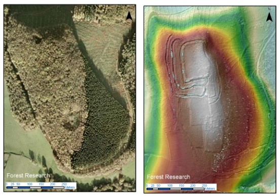
A special plane equipped with cutting edge technology is being used next week to search for the lost archaeology hidden under the South Downs National Park’s ancient woodland. While the South Downs are famous for Iron and Bronze Age monuments such as Cissbury Ring and Winchester Hill, a large part of the central areas of the national park lie under forests or woodland and almost nothing is known about their ancient history. The Piper Chieftain survey aircraft will be using airborne laser technology (commonly known as LiDAR) to map the ground underneath 30,000ha of woodland between the river Arun and the A3.

Rebecca Bennett said: “It’s a unique opportunity to unlock the secrets underneath these ancient woods. There are a few archive aerial photographs of this area capturing a tantalising glimpse of features revealed by felling during the second world war, but there is so much we don’t know about the history of the people who lived here.”

Our earlier post on this project is here.

Richard Rogers vs Mayfield Market Towns

22 Parkside Wimbledon, designed by Richard Rogers
The architect Richard Rogers has joined the campaign against Mayfield.

Existing settlements already contain ‘live, work and leisure’; public transport, schools, hospitals, churches, meeting halls and existing social and physical infrastructure. Greenfield land has none of these facilities in place and therefore it will mean that more cars, roads, sewers, etc. will be required which is why it is not environmentally sustainable.

Full report here.

Ham Fields Forever

Ham Fields
The Mid Sussex Times reports:

Opposition is growing to controversial plans for 97 homes on greenfield land near one of the most polluted crossroads in Mid Sussex. .. The South Downs National Park Authority says the scheme would be seen from Wolstonbury Hill and “have the potential for significant adverse impact on the national park”.
..
Access to the site would be off London Road, which has an average daily weekday traffic flow of 14,000 vehicles. West Sussex Highways officers have expressed concern about road safety and the impact on Stonepound Crossroads, which, in their words is “subject to severe congestion”.

The Poynings burglars

Michael Griffiths murder police poster
The Chichester Observer has extended reports on a murder trial with a local connection. Here are some extracts:

Penton, 43, of Markway, Sunbury, denies murder and conspiracy to pervert the course of justice, but has admitted conspiracy to burgle homes in Loxwood, Poynings and a home near Godalming as well as Mr Griffiths’s home.

The jury also heard how the burglary at Poynings on May 24, 2103, to which Penton has pleaded guilty, came after he found the house in Country Life magazine.

John Bartholomew, 72, of Cross Street, Portsmouth, denies murder and conspiracy to commit burglaries in Loxwood, Fernhurst and Poynings.

Harvey Munford, 23, of Monks Way, Staines, has admitted conspiracy to burgle homes in Loxwood, Poynings and Godalming, conspiracy to burgle Mr Griffiths’ home and conspiracy to pervert the course of justice. He denies murder but has pleaded guilty to manslaughter.

The murder of Michael Griffiths has been described by both a forensic pathologist and a police inspector as the ‘most complex’ case ever seen.

Much more here and here.