Green and Pleasant Land

Swanbourne Lake

Swanbourne Lake, Arundel

A five week WEA course on the great South Downs estates to be taught by Janet Sinclair at Penfold Hall in Steyning, Tuesdays 2:30pm–4:30pm, from 3rd February to 3rd March 2015. Topics to be covered include the great families, their homes and estates (Arundel, Petworth, Goodwood); demise and rebuilding (Cowdray, Stansted Park, Uppark House, Parham, West Dean, Pallant House); those who worked and lived on the estates (Stansted Park, Petworth); etc. More information and booking details here.

Mineral Sites Study

Shoreham Cement Works chalk extraction site
The Mineral Sites Study [PDF] is a recently published document deriving from the joint SDNPA/WSCC exercise known as the Minerals Local Plan. Despite four pages devoted to a potential seventy acre gravel pit on a greenfield site in Woodmancote*, there is little in it to interest a resident of Fulking or Edburton. The one possible exception is a five page section [PDF] devoted to Shoreham Cement Works. There’s a lot of chalk left, apparently, and a planning permission for further extraction that runs until 2042, a fact that appears to have come as an unwelcome surprise to the current generation of planners (as it may to future generations of the ‘rare breeding birds’ who have made the site their home). If you feel inclined to respond to the study, then WSCC provide a form here.

*Not our northern neighbour but a different village, located to the west of Chichester.

SDNPA Photo Competition 2014

Box Brownies negative
Deadline midday Monday 13 October 2014. Modest prizes on offer. Your ‘hidden gem’ image must be taken within the official boundaries of the South Downs National Park. You must specify where the image was taken. Bonus points if you use public transport to locate your ‘hidden gem’. You must not submit any photographs that are obscene, vulgar, pornographic, hateful, threatening, racist, sexist, discriminatory, disrespectful to the SDNPA, or which otherwise violate any local or international laws. No nudity is allowed. Animal subjects must complete model release forms. Entrants under the age of eighteen must have the signed permission of the local Park Ranger and their parent or guardian. Children and babies must be wearing at least a nappy, as must the photographer. By entering the competition, you grant the SDNPA an irrevocable license to reproduce, enlarge, publish or exhibit your photograph(s) on any media they choose. SDNPA reserves the right to cancel or amend the competition, the rules and the terms and conditions of entry at any time and without prior notice. More here.

SDNPA issues first article 4 direction [update 2]

Soberton view
The Hampshire Chronicle reports the views of the farmer in the case:

The national park misrepresented the situation. They have decided that because I repositioned a gateway that I was going to sub-divide the field. They have used their powers wrongly. They have stopped us putting stock there. They have misused the legislation. The trouble with the national park is that they have too much power. They should have come to me and consulted me. At no point was I going to sub-divide or put horses there. I have spent a lot of money restoring the field to meadowland from arable. The national park is wasting everybody’s money. Authority gone mad. They have taken away my right and I cannot even put cattle in. The park authority is jumping because a few people make a fuss.

Our earlier posts are here and here.

More open access land

B&HCC release more open access land
The Argus reports:

Brighton and Hove City Council has created free public access to another 670 acres of Sussex downland. .. Five miles of new footpaths and bridleways have been created, meaning walkers on the Sussex Border Path can divert on to a route keeping them further away from busy roads. Works have involved installing gates and cutting a new path up a steep bank at Braypool. .. The surrounding landscape includes ancient burial mounds on top of Tegdown Hill, lynchet terraces .. and the Chattri monument.

Mile Oak Farm Open Day

Mile Oak Farm
Saturday 26th July, 10:00am onwards, free admission, proceeds to local charities.
Trailer rides, traction engines, vintage tractors, farm animals, donkey rides, ferret racing, dog scurry racing, airgun target shooting, archery, barbecue, ginger wine, and real ale.

The farm is due south of Perching Manor and you can walk there from Fulking without crossing a single public road. There are two quite different routes so you can make an interesting circular walk out of a visit. A copy of OS Explorer 122 will prove useful if you haven’t done it before.

A sermon on Tottington Mount

Tottington Mount versus the Rampion trench
Readers of the Yr Arolygiaeth Gynllunio report [PDF] cannot help but notice that the inspectors were much exercised by Tottington Mount. It is discussed or referenced on no fewer than 32 pages. By contrast, there isn’t a single reference to Truleigh Hill anywhere.

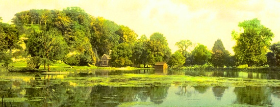
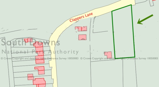
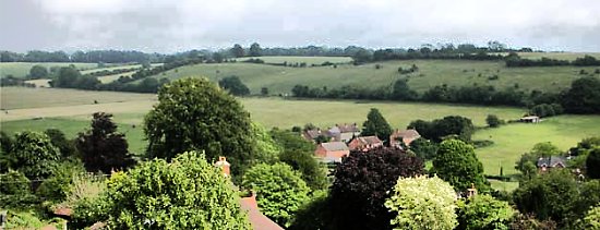
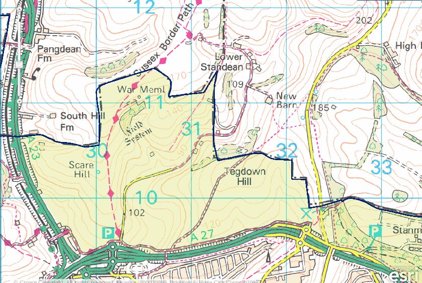
Tottington Mount lies between the Truleigh Hill Youth Hostel and Tottington Manor Farm. There is a public footpath opposite the farm that will take you up and across the mount. It is extremely steep for much of the route. Apart from the splendid view to the north, there’s not much to see. You will pass a long low earthwork as you near the summit. The mount itself just looks like canonical downland to an inexpert eye. As the map above indicates, the trench will bisect the mount.

Tottington Mount is a virgin patch of Downs that has never been ploughed. As a consequence, it hosts noteworthy plant species (page 57). The works area for the trench is to narrow from 30-40 metres to 20-30 metres as it cuts across the area (page 94). E.ON will be spending £330K on bog matting and other mitigation expenses on this small section of the trench (page 38). Some details of the mitigation plans, and the SDNPA’s scepticism about them, can be found on pages 57-58. The inspectors think that these mitigation efforts may well fail (page 41). The trench will skirt the Beeding Hill to Newtimber Hill SSSI (Site of Special Scientific Interest) with a margin of about 50 yards at Tottington Mount. Disturbance to the chalk grassland species living within the SSSI will be ‘negligible’, apparently. Indeed, these species are set to benefit significantly from all the environmental monitoring that will be happening at Tottington Mount as part of the mitigation exercise (pages 52-53). However, Adonis Blue caterpillars may not share this upbeat view — they risk losing their lunch (pages 67-68).

The earthwork is a Bronze Age cross dyke and is listed as an ancient monument. The trench will go right through it (click the map above to see the detail of this), something that English Heritage refers to as a “substantial harmful effect” (page 178). The good news is that archaeologists will be funded to root around in the rubble — “appropriate archaeological supervision” (page 179, pages 398-399) — and English Heritage felt able to rule that “the harm is necessary in order to deliver substantial public benefits that outweigh the harm” (page 178). In turn, the inspectors concluded that there will be “be no loss of significance of any designated or undesignated heritage asset” (page 182) notwithstanding the “risk of adverse effects upon heritage assets, including the Tottington Mount Scheduled Ancient Monument” (page 227).

GJMG

Not on the buses

Not on the buses
A recent press release from the SDNPA claims that “additional funding for 2015/16 will deliver a series of innovative new initiatives such as .. Wi-Fi on rural bus services”.

What more justification could you need for the purchase of a shiny new 17″ laptop to perch on your knee as you travel to Horsham on the No 17? Answer: a lot.

Wi-Fi-on-rural-bus-services is crazy talk and it isn’t going to happen. If you need convincing, read on.