
 National Severe Weather Warning Service – Chief Forecasters Assessment
A strong, high-level jet is expected to engage warm low level air to give rise to a rapidly moving low pressure system later on Sunday. This is expected to run northeastwards, probably across England and Wales, with very strong winds on its southern and western flanks.
There is the potential for gusts of over 80mph, especially on exposed coasts, bothin southwesterly winds ahead of the low and west to northwesterly winds behind it.
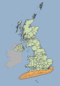
The Met Office have issued an Amber Alert of Wind
Valid from 00:05 on Mon, 28th Oct 2013 until 21:00 on Mon, 28th Oct 2013
A very intense low pressure system is forecast to run northeastwards across the countryearly on Monday, bringing the potential for an exceptionally windy spell of weather for southern parts of the UK. At the same time, persistent, heavy rain could cause some surface water flooding.
At this early stage there is uncertainty about the timing, intensity and track of the low. However, the public should be prepared for the risk of falling trees as well as damage to buildings and other structures, bringing disruption to transport and power supplies.
For more details please go to: http://www.metoffice.gov.uk/public/weather/warnings
Issued by the Met Office at 10:38 on Thu, 24th Oct 2013