Fulking Parish Council — Meeting Thursday 10th April 2014 at 7:30pm

In the Village Hall. Members of the press and public are welcome to attend.

Agenda

  1. Chairman’s Welcome.
  2. Apologies.
  3. Declaration of Interest.
  4. Approval of minutes 9th January 2014
  5. Matters Arising from the above minutes not on the agenda (to include Planning inc. Old Pump House, Highways Flooding & Operation Watershed, Lady Brook Spring, Footpath 4f update, Winter Management, NTF Trees).
  6. Reports from District & County Councillors.
  7. Preston Nomads
  8. NTF mowing contract
  9. Water Fountain
  10. Fireworks
  11. Financial Matters (including Cheque List & Stubs, Income & Expenditure to date, quarterly bank reconciliation), Financial Regulations.
  12. Annual internal audit.
  13. Annual Parish meeting speaker update & refreshments.
  14. Thank you — Street Light, Table, NTF Trees & Fencing
  15. Comments from the floor.
  16. Dates of next meetings.

Andrea Dickson, Clerk to Fulking Parish Council
01444 451 060 / andreadicksonfpc@gmail.com

Reconfiguration ~ Transfiguration

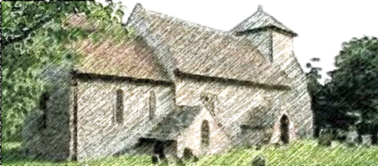
Pyecombe Church
Work has started on the new loo and kitchen at Pyecombe Church. The Reverend Caroline Currer comments:

The church is the only public meeting place available in the village, and is used for meetings and events such as parish council meetings. We believe the extension and its facilities will encourage the start-up of smaller local, social groups such as coffee mornings and informal meetings. In addition, the toilet facilities will encourage greater links with the many hundreds of charities and groups who organise sponsored walks, bike rides and the challenges along the South Downs Way.

Cross the A283 and live! [update 2]

Bridleway crosses A283
The Shoreham Herald reports that WSCC Rights of Way Committee has now agreed to the new bridleway that will allow users of the Downs Link to avoid having to cross the A283:

It will run close to the River Adur, passing under the A283 road bridge, through a field, across a ditch and through a wooded highway verge to rejoin the Downs Link at its existing crossing point. It adds 970m to the length of the route.

Removal of overhead power lines

Eyesore on the ridge above Fulking
The South Downs National Park Authority has a relevant press release:

Local residents and walkers using footpaths around the South Downs village of Cocking now have a clearer view, thanks to a £25,500 scheme by Southern Electric Power Distribution (SEPD) to remove nearby overhead power lines. .. SEPD engineers have recently completed a three month project to replace overhead electricity lines from land near the church with replacement underground cables. Three spans of power lines have been taken down and four wooden poles. .. The project was funded by a special allowance, granted to SEPD by industry regulator Ofgem, to invest in projects to underground power lines in AONBs and National Parks in central southern England.

Cross the A283 and live! [update]

Bridleway crosses A283
The Shoreham Herald reports:

A new bridleway designed to make the Downs Link at Bramber safer is receiving wide support. West Sussex County Council is consulting on plans to create a new route, parallel to and under the A283, to avoid crossing the busy main road. Jon Perks, principal rights of way officer, has written to residents and landowners for comments on the £77,000 scheme, which should be returned by February 20. .. The new route would pass under the bridge that carries the A283 over the River Adur, 500m south-east of the existing crossing point. It would add about 970m to the route but it is thought the safety benefits outweigh the extra distance to travel, plus, the existing crossing point will remain open for ‘confident’ cyclists and others who wish to take a more direct route. Part of the land is owned by the Crown Estate, which has said it will not raise objection. The track on the south side of the A283 is shared by the county council and a private landowner and both are willing to dedicate it as a bridleway.

Snow on the Bomb House

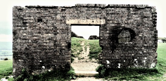
The Bomb House near Devil's Dyke, South Downs, Sussex
Fulking residents see it every day as they look up at the Downs. But what is it? When was it built? Why is it in that location? Is it a relic of the Napoleonic wars? Was it once a semaphore station? A camera obscura? Did it play a role in James Hubbard’s Victorian recreation complex on the Dyke? Why is it called “the bomb house”? Did it ever have a roof? Why is it half full of earth? Why are several walls damaged? Is Canada to blame?

You’ll find out the answers to these questions, and many others, if you attend Martin Snow’s talk The Devil’s Dyke — Pleasure Ground to Bombing Ground at the Beeding & Bramber Local History Society meeting at 7:45pm on Wednesday 2nd October in the Village Hall, Upper Beeding.