The manor of Perching

Gules fleur de lis argent
Gules fleur de lis argent: the arms of the wealthy and influential Aguillon family who held the manor of Perching for much of the 13th century.
Nowadays, we think of ‘a manor’ as being a house, probably a modestly grand one (but immodestly grand if built and named recently), or as police slang from the days of The Sweeney. However, for a significant part of England’s history, a manor was primarily a feudal estate and a local administrative and judicial unit. If the lord of the manor lived in a house on the estate then that house would have been known as the manor house. The estate typically contained farms and these were operated either by the lord of the manor himself or by tenants. Manors could be quite large: they might subsume an entire parish or even spread over more than one. In the case of Edburton, the historic parish contains four small manors: Aburton, Paythorne, Perching and Truleigh. Of these, Perching was by far the most important, especially during the Aguillon incumbency.

The four manors of Edburton, in common with others found along the South Downs, are oddly arranged to the modern eye. Together with Fulking*, they partition the parish into long thin irregularly shaped strips running from south to north. The explanation for this topography lies in the fact that the manors owed their existence to farming. Each manor was a self-contained mixed farming zone:

Each had its chunk of Down pasture, its rich malm and greensand arable under the Downs, its sticky wooded patch of gault clay beyond, and fertile lower greensand at the northern end. .. Each of the farmsteads had a daughter farm to the north on the lower greensand — Truleigh Sands, Edburton Sands, Nettledown, and Perching Sands. The woods of Tottington Longlands and Perching Hovel mark the poorly drained gault clay.
[Bangs 2008, page 216]

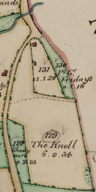
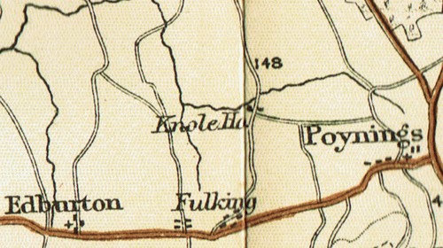
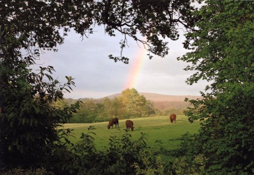
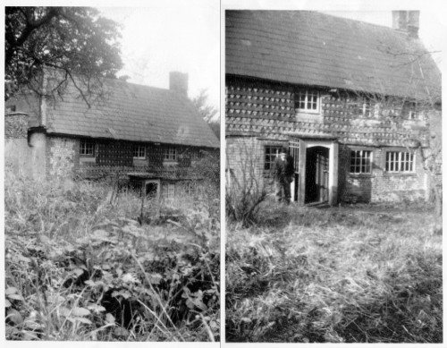
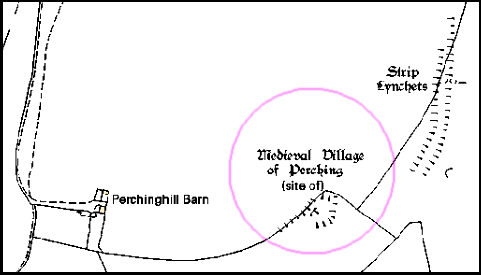
Sheep were grazed on the Downs, the northern escarpment provided chalk for lime and springs for a water supply, and the weald provided suitable land for crops, cattle, and rabbit warrens as well as woods providing timber and charcoal and a home for swine. In addition to the northern daughter farms listed by Bangs, at least some of the manors once had southern daughter farms located on the top of the Downs. Thus Paythorne had Summersdeane which had survived as a farm from Saxon times until Canadian tanks used it for target practice during WWII. In the case of Perching, the southern farm was probably located at the deserted medieval settlement to the east of the modern, but now dilapidated, Perching Hill Barn buildings.

Site of the medieval_village of Perching
The site of the medieval settlement on Perching Hill. Note the strip lynchets — ploughed cultivation terraces. There was an underground water supply available, currently attested by the well adjacent to Perching Hill Barn.
Perching had a watermill in 1086 when the Domesday Book was compiled. This was used to grind the grain grown by the lord of the manor and his tenants. The latter had no choice — they had to use their lord’s mill and pay for the privilege. The mill was located at the north end of the estate and had fallen out of use by the end of the eighteenth century. Howe [1958, page 22] notes the remains of a mill hatch which may mark the location.
Diagram of a Domesday-era water mill
After detailing the somewhat complex genealogy that explains how Perching came to the Aguillons, Howe goes on to tell us that:

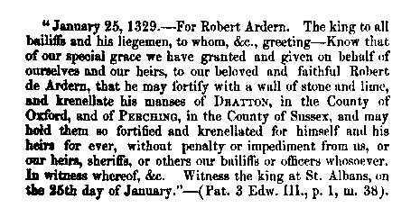
Perching was now in the hands of a powerful family of considerable note. They were important in the county, for thirteen legal decisions are extant on their tenure of properties in Sussex other than Edburton between 1190 and 1298. They also held estates elsewhere, from one of the chief of which, Addington in Surrey, much can be learned which is of interest for Edburton. They were important to the crown as holding Addington by a service of cookery at coronations. The obligation was no doubt a proud privilege, just as to this day are the duties of bearing certain of the insignia at coronations. The duty is defined as “a sergeantry of making a hotch-potch in a yellow dish in the king’s kitchen on the day of his coronation or by deputy”. Perching was not held by this service, but the succession at Addington and Perching had been the same. The first Norman tenant of both had been Tezelin, the Conqueror’s cook. It is not only that the two manors were so closely connected, nor even the flavour of the kitchen, that is the most significant, but that the family was so closely tied to the crown at a time when so many of the feudal lords were in revolt. Robert, the son of William, and his heir and successor at Perching, was a devoted royalist, in whom the king had such confidence as to allow him to fortify his manor-house. In 1264 a licence [to crenellate] was granted. Meanwhile, Robert had died, in 1261, and in 1268 the licence was renewed to his son, also named Robert. [Howe 1958, pages 8-9]

In contrast to Victorian times, the desire to crenellate a manor was not an aesthetic matter, nor an academic one. The king would have wished to ensure that his supporters were in a position to defend themselves. This was a period when the king and the barons were in dispute. Robert Aguillon was loyal to the king but his overlord, the Earl of Warenne was a militant baron. Relations between them were not good as this document of a prosecution for trespass from 1274 demonstrates:

To the sheriff of Sussex. Whereas the king, at the prosecution of Robert Aguillon, lately ordered him to move the men of John de Warenne, earl of Surrey, archers and other armed men, who wander about Robert’s manor of Percynges and about his other lands, and lie in wait by day and night for his men, and aggrieve and disquiet them, from the said manor and lands, and the archers and other armed men, although warned by the sheriff on the king’s behalf to depart quietly from the manor and lands, still remain there doing worse damage to Robert and his men, whereat the king is moved: the king therefore orders the sheriff, if the archers and men still remain there and refuse to depart, to take them and keep them in prison until otherwise ordered. [Calendar of the Close Rolls, Henry III, 27th March 1274, quoted by Howe 1958, page 9]

When the younger Robert died, in 1286, Perching manor alone had been providing him with an income of around £100,000 per annum in today’s money (calculated on the basis of the relative price of eggs). And he was the lord of many manors.

The site of the original Perching Manor House
The building that the Aguillons sought and gained permission to fortify was not, of course, the house that we know as Perching Manor today. The thirteenth century Aguillon manor house stood midway between Paythorne and Perching farms in what is now a field, Frog Holt, immediately south of Perching Hovel Wood. Howe remarks that “it is not known when [it] ceased to be occupied or when it was demolished” [1958, page 33]. There’s not a lot left to see though a portion of the moat persists.
Crenellation licence issued to Robert Ardern 1329
Fortification of the manor continued in the fourteenth century
In the fourteenth century, Perching passed into the hands of the de Arderns, then Sir Michael de Poynings and thence, by marriage, to the Earls of Northumberland. When the 6th Earl was executed for treason in the sixteenth century, all his property was confiscated by the crown. The king then granted Perching to the father of the first Lord Montague (of Cowdray). When the last Lord Montague died, at the end of the eighteenth century, the estate returned to the crown. Throughout the seventeenth century, Perching was held by the Colstock family as tenants of the Montagues. During the time of the Rump Parliament, Thomas Colstock, a royalist, found himself having to appear before the sinister but delightfully named Committee for Compounding with Delinquents in order to retain control of Perching.


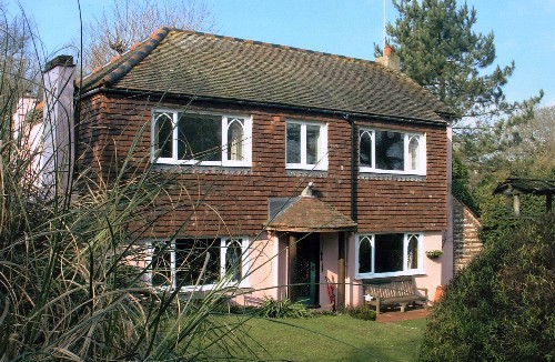
*The manorial status of Fulking is complex. It was once a component of the manor of Shipley, then became detached and was eventually absorbed by Perching [see Howe 1958, page 6 for the details]. The Old Farmhouse may have been the manor house.

References:

  • Dave Bangs (2008) A Freedom to Roam Guide to the Brighton Downs. Portsmouth: Bishop Printers.
  • F.A. Howe (1958) A Chronicle of Edburton and Fulking in the County of Sussex. Crawley: Hubners Ltd. [The definitive source on the early history of Perching. Most of the information presented above comes from Howe’s book.]
  • L.F. Salzman, ed. (1940) A History of the County of Sussex, Volume 7: The rape of Lewes. London: Victoria County History, pages 202-204. [This contains a lot of detail on the early history of Perching, albeit in a much less readable manner than Howe. But, unlike Howe, it is just a click away.]

GJMG

Updated 2nd March, 2013.

Currently popular local history posts:

Characteristics of National Parks


The ONS has just released a report [PDF] on the national parks in England and Wales based on the 2011 census. Residents of the South Downs National Park (SDNP) should find some of the content to be of interest:

  • The population of the national parks taken as a whole has increased by 7,400 since 2001. Of this, the SDNP is responsible for 7,200.
  • The population density of the SDNP is the highest of any national park and 36 times greater than that of the Northumberland park.
  • The SDNP had the lowest median age at 46 (compare the Broads and Exmoor, both at 53).
  • National park residents are older than the general population but consider themselves healthier: 82% describe their health as good or very good. The SDNP has the highest proportion who describe their health as very good.
  • Among the parks, the SDNP has the lowest proportion of UK born residents at 91% (the figure is 87% for the population as a whole and 97% in Snowdonia).
  • 40% of SDNP households occupy detached houses or bungalows (the figure is 23% for the population as a whole and 66% for the New Forest).
  • The SDNP has the lowest proportion of homes with “no usual residents” at 6% which is a bit higher than the national average but much lower than the national park average (14%) and the Pembrokeshire Coast (28%).

GJMG

Living in vans on the Downs

Living in a van
Van dwellers appeal eviction notice
The Argus reports:

The group of van dwellers have been on the site, which is in South Downs National Park .. for at least four months. When The Argus visited earlier this month, it included a university student, a roller-skating teacher and a telesales worker. Some members of the current encampment were part of a group which was evicted from land bordering Devil’s Dyke Road in May 2012.

Ward councillor Ken Norman .. said “The big issue here is human rights, whatever they are.”

Illegal encampments can be reported to West Sussex County Council by contacting Esther Quarm on 033 022 23736 or email esther.quarm@westsussex.gov.uk

Road Closures

Road_Closed_Sign

Carriageway Patching to_Clappers Lane. Fulking: ref#_9110137

West Sussex Highways will shortly be improving the surface of Clappers Lane. This work will commence on the 25th February 2013 and will last 2 days.

This process will involve removing the surface layer of tarmac, then replacing with new material.

Due to the large plant used to surface the carriageway a road closure will be in operation to enable us to safely carry out these works in a timely manner. This closure will be in place along the whole length of Clappers Lane, and will be in force between 0800 and 1700. A signed diversion via A281, Poynings Road will be in place.

Before the work starts ‘advance warning’ signs will be erected stating the start date, duration and marking the extent of the works. We shall do our utmost to minimise the impact of the works and you can help us by following this advice:-

  • On the day of the works please don’t park on the road unless you have off street parking.
  • Access to your properties will be maintained where possible: however during periods when materials are being laid access may be limited
  • For safety and cleanliness reasons please do your utmost to keep children and pets away from the area of work
  • When driving on the new surface please keep to the signed temporary speed limits and avoid heavy braking to allow the surface to stabilise

Whilst work is being carried out we would ask that you follow any instructions given by the expert personnel on site. If you have any concerns about access please speak to the site foreman who will be happy to help you.

Please note that the date of this work may change in exceptional circumstances.
Yours faithfully
West Sussex Highways

Knole House

Edburton Tithe Map 1842
Knole House is the red square near the top of this 1842 map excerpt.

Prior to the twentieth century, there was very little housing in Clappers Lane. The present Knole House is built on one of the oldest residential sites. There was a small cottage on the site in 1701 and the cottage was probably built some time before 1650. That cottage seems to have endured for three centuries. On the north side there is an old droveway which originally linked farms in Poynings with Clappers Lane. There was a small orchard in the southern part of the grounds, which is gault clay. There were still about forty fruit trees there in the early 1950s. Immediately due south of the property is a field called The Knoll.

Census records show that the cottage was occupied by the Hurssey family in the mid-nineteenth century. In 1841, Daniel Hurssey, his wife, and two adult sons are listed at Clappers, but this is most probably a reference to the area rather than the to house of that name, which was just across the road from Knole House. By 1851 one of the sons had married and fathered a child. All six were living in Knole House and the occupation of each of the three adult males is listed as market gardener. In 1861, Daniel, now aged 74, has become a widower and is living in Knole House with an adult grandson and a female servant from the Beard family. One of his sons is living elsewhere in the village with wife and child.

By 1871, all the Hursseys have left the parish and Henry Sayers, a widower, has moved into Knole House with three children and a housekeeper. Like Daniel Hurssey, Henry was a market gardener and he had already been living in Fulking for at least twenty years. By 1881 he had remarried and he and his second wife remained at Knole House until at least 1901, when Henry was 79.

Nowadays, Knole House is shielded by trees and cannot be easily seen from the lane. But the location is explicitly marked and named in many old maps. This example from a 1898 guide book to Sussex suggests that it was a landmark at that time. It may be that the adjacent ford provided a watering place for horses.

At some point during the early years of the twentieth century, the cottage passed into the hands of Henry Young, a builder whose firm was called ‘H.Young & Son’. He was contracted to construct Fulking Village Hall in 1925/26. Henry’s son Sid and his wife May subsequently inherited the cottage and lived there. May Young, a pleasant, cheerful lady with a good sense of humour was the district nurse for the local villages, who at first made her calls on a bicycle, but was later provided with a car to make her rounds. In those days there was no local health centre with up to date facilities nearby. A visit to the doctor had to be paid for and admission to hospital cost a great deal of money. Nurse Young was thus the first person to receive a cry for help for any medical emergency. Even today, some of the older village residents recall being told that they were delivered at home with her assistance. The Youngs also sold fruit from the trees in the garden. When Sid Young died, May moved initially to Primrose Cottage, and later to Teapot Row, in The Street, Fulking. She put Knole House on the market, but it remained empty for some time.

The View from Knole House
The view of Wolstonbury Hill from Knole House around 1990, much as it would have been 300 years earlier.

When the Youngs lived in the cottage, they used the adjacent stream as their water supply just as all the previous residents had. There was no electricity (or gas) so lighting required candles or oil lamps. There was no sanitation. Nothing much had changed since the cottage was built — except that the quality of the water available from the stream had deteriorated thanks to chemical run-off from the fields. Furthermore, the foundations of the cottage, which sat on greensand, were unsound and needed serious attention. Despite the idyllic location, it is little wonder that the cottage remained empty — it was not in a condition that would have attracted domestic buyers in the 1950s.

Two mid-C20 snaps of Knole House
Two snaps of Knole House as it was prior to Ray Nobbs’s reconstruction in the mid-1950s. Note the porch, the steeply pitched slate roof, the small-pane windows, and the very distinctive patterned tile hanging. The young man in the picture on the right is Ray’s son Chris.

Knole House was purchased in 1954 by Ray Nobbs. Ray was a builder who had the skills that were needed to rescue the cottage, and the vision to see what it could become. He demolished much of it but then rebuilt it on sound foundations in exactly the same location. Parts that were retained, including at least one of the end walls and the associated fireplace and chimney stack, had to be excavated and then underpinned with concrete. The original cottage had had a roof with a relatively steep pitch with slates at the front and tiles at the back. The rebuild had a roof with a shallower pitch and tiles throughout. Chris Nobbs notes:

During renovations Dad unearthed what we thought was a fourteenth century window, from looking at old churches. This was at the back of the house where the old walls were massive and built of flint cobbles, previous occupants had a kitchen here of sorts, it had a very old sink anyway. Down a few steps from here was a kind of cellar with grills to the outside admitting a little light, there were several rings in the floor and we thought that long ago livestock may have been kept. That is actually below the present kitchen extending to the conservatory. The wall at the front was old tiles and brick but beneath that we discovered the original massive oak beams which formed the superstructure and between were laths plastered with wattle and daub.

An immediate priority was the water supply: Ray enlisted the services of Mr Spronket, water diviner, and then dug a well in the grounds, a well which still functions today. And, in the 1960s, Ray was instrumental in securing a mains water supply for the houses in Clappers Lane. In his reconstruction, Ray used materials salvaged from the original cottage and from various old houses and churches in the Brighton and Hove area that had been demolished. As a consequence the house has many interesting features including an old gallery staircase; large, very heavy, solid wooden doors; and a unique front door, along with beams and attractive arches in the hall. One feature that he restored was the linhay, a lean-to shed attached to the north end of the house. This linhay was to assume an interesting role in the subsequent history of the house.

Knole House as it was in 2007
Knole House as it was in 2007. Note the conical porch, the shallow pitch Keymer-tiled roof, the first floor hanging tiles, the distinctive windows with their gothic sidelights, and the side-wall of the linhay on the right.

In 1987, Ray Nobbs and his wife moved to a bungalow in Hassocks. They sold Knole House to Jill and Nick Bremer. The Bremers made some further architectural changes, most notably restoring Keymer tile-hanging to the front of the house (which had been left rendered by Ray). They retained the unusual conical porch that Ray had installed. They converted the attic over the garage, formerly the shed for a carriage, into a proper room with a view over the fields. The linhay had been in use for storage and as a utility room. The Bremers doubled its size, re-roofed it with glass, and converted it into an artist’s studio. When the Bremers sold the house in 2007 and moved to Devon, the buyer was another professional artist, one who continues to use the linhay as his studio.

Tony Brooks

Maps

  • The Edburton Tithe Map, 1842 [digitised by the West Sussex Record Office, Chichester].
  • Map of the Brighton area by J. Bartholomew and Co., reproduced in A.R. Hope Moncrieff (1898) Black’s Guide to Sussex and its Watering Places. London: Adam and Charles Black, facing page 30.

With thanks to Chris Nobbs for reminiscences of his time at Knole House and to Jill and Nick Bremer and to James Lightfoot for their help with source materials for this post.

[Copyright © 2013, Anthony R. Brooks. Adapted from Anthony R. Brooks (2008) The Changing Times of Fulking & Edburton. Chichester: RPM Print & Design, pages 84-85.]

Updated to include reference to Henry Young, 9th February 2015.

Currently popular local history posts: