Landfill Communities

A landfill community
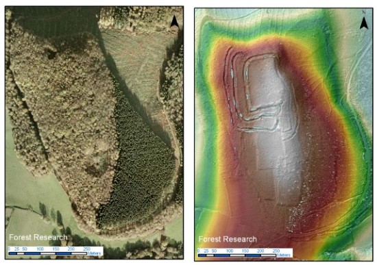
The South Downs National Park Authority reports:

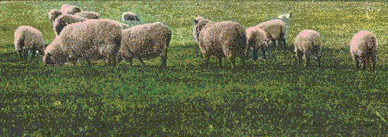
The Veolia Environmental Trust have awarded a grant of £40,000 through the Landfill Communities Fund which is helping to improving the chalk grassland near Saddlescombe Farm, Brighton, where rare and threatened butterfly species such as the Small Blue, Chalkhill Blue and the Brown Argus can still be found. The funding means that newly improved chalk grassland on the edge of Waterhall Golf Course will join up with chalk grassland already managed by Brighton and Hove City Council — increasing the area that the butterflies can call home by 50 per cent.

Mapping the woods [update]

Aerial photo versus LiDAR showing hidden archaeological features

A regular aerial photo compared with a LiDAR image of the same area. The latter reveals archaeological features that are hidden in the former.

The Midhurst and Petworth Observer reports that:

A special plane equipped with cutting edge technology is being used next week to search for the lost archaeology hidden under the South Downs National Park’s ancient woodland. While the South Downs are famous for Iron and Bronze Age monuments such as Cissbury Ring and Winchester Hill, a large part of the central areas of the national park lie under forests or woodland and almost nothing is known about their ancient history. The Piper Chieftain survey aircraft will be using airborne laser technology (commonly known as LiDAR) to map the ground underneath 30,000ha of woodland between the river Arun and the A3.

Rebecca Bennett said: “It’s a unique opportunity to unlock the secrets underneath these ancient woods. There are a few archive aerial photographs of this area capturing a tantalising glimpse of features revealed by felling during the second world war, but there is so much we don’t know about the history of the people who lived here.”

Our earlier post on this project is here.

Ham Fields Forever

Ham Fields
The Mid Sussex Times reports:

Opposition is growing to controversial plans for 97 homes on greenfield land near one of the most polluted crossroads in Mid Sussex. .. The South Downs National Park Authority says the scheme would be seen from Wolstonbury Hill and “have the potential for significant adverse impact on the national park”.
..
Access to the site would be off London Road, which has an average daily weekday traffic flow of 14,000 vehicles. West Sussex Highways officers have expressed concern about road safety and the impact on Stonepound Crossroads, which, in their words is “subject to severe congestion”.

Iconic views


The Sussex Express reports the Director of Planning for the South Downs National Park, Tim Slaney, as saying:

The Rampion wind farm proposals would harm the landscape and cultural heritage of the South Downs National Park introducing 175 turbines into the iconic views from the Sussex Heritage Coast and cause large scale disruption to the landscape of the National Park through the construction of a 14km long and 30m wide cable corridor.

The South Downs National Park Authority (SDNPA), which attended 11 days of public examination and submitted in excess of 270 pages of evidence, recommended that the Secretary of State should refuse to grant permission to ensure that the landscape and cultural heritage of the National Park is conserved.

Wealden wins

Wealden CSLP
The Sussex Express reports:

A consortium of landowners have failed in a High Court bid to tear up Wealden District Council’s housing plans for the next 16 years and force it to go back to the drawing board.

One of the country’s top judges dismissed the challenge brought by the group, known as Ashdown Forest Economic Development LLP, to the Council’s Core Strategy Local Plan (CSLP.)

The group claimed the Council, the South Downs National Park Authority and a Government planning inspector who had cleared it to be adopted had been too cautious and protective of the environment and nearby Ashdown Forest. However, Mr Justice Sales today rejected all of the group’s grounds of complaint.

More details at the link.

Removal of overhead power lines

Eyesore on the ridge above Fulking
The South Downs National Park Authority has a relevant press release:

Local residents and walkers using footpaths around the South Downs village of Cocking now have a clearer view, thanks to a £25,500 scheme by Southern Electric Power Distribution (SEPD) to remove nearby overhead power lines. .. SEPD engineers have recently completed a three month project to replace overhead electricity lines from land near the church with replacement underground cables. Three spans of power lines have been taken down and four wooden poles. .. The project was funded by a special allowance, granted to SEPD by industry regulator Ofgem, to invest in projects to underground power lines in AONBs and National Parks in central southern England.

Flood inhibition

SDNPA flooding
Six hundred trees are being planted on farmland in the South Downs National Park to help prevent a repeat of recent flooding and soil erosion.

David Hamilton Fox, who manages the Cowdray Home Farms, in West Sussex, said: “The River Rother in the heart of the South Downs National Park floods most years but this winter has been particularly bad. As well as misery for locals we have lost a considerable amount of topsoil, which is vital for growing crops, and will eventually increase the silt in the river – perhaps leading to more flooding.

More here.