
Category: Public Footpath
Parish Council Meeting – 14th April 2016 7:30pm – Village Hall
Fulking Parish Council will hold their quarterly meeting at 7:30 on Thursday April 14th 2016 in the Village Hall — agenda. Members of the Press and Public are welcome to attend.

Local Walks
Footpaths needing attention
The Parish Council has been advised that our local Access Ranger will be arranging Public Rights of Ways inspections next month. Following these inspections, routine maintenance work will be organised.
If anyone is aware of any issues or work that needs doing, please contact West Sussex Public Rights of Way by the end of March via the following email address: prow@westsussex.gov.uk. Please copy in the Parish Council for our records (parishclerk@fulking.net).
Path numbers can be found on the iMap on the West Sussex website and you may find it useful to refer to the ‘how to use the iMap’ for this. Both the map and the guide can be found via the following link: www.westsussex.gov.uk/imap.
Kate Watson
Parish Council Meeting – 14th January 2016 7:30pm – Village Hall
Fulking Parish Council will hold their quarterly meeting at 7:30 on Thursday January 14th 2016 in the Village Hall — agenda. Members of the Press and Public are welcome to attend.
4F’s sake
Parish Council Meeting – 8th October 2015 7:30pm – Village Hall
Fulking Parish Council will hold their quarterly meeting at 7:30 on Thursday October 8th in the Village Hall — agenda. Members of the Press and Public are welcome to attend.
Footpaths needing attention
WSCC have changed the way that the Public Rights of Way are managed and maintained. They will now be inspected once every fifteen months as opposed to once every nine months. At the same time, WSCC are looking at the summer clearance programme for footpaths. This programme clears surface vegetation on approximately 10% of the network.
If you know of any footpaths/rights of way that need attention please can you inform me before the 8th January 2015 or in person at the PC meeting on that day. The PC will then advise WSCC.
Andrea Dickson
Clerk to the Parish Council
01444 451 060/andreadicksonfpc@gmail.com
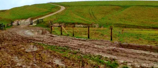
Mud on the Downs
Charlie Cain, the National Trust’s Head Warden for the South Downs, writes:
The situation is not ideal and it is our intention to remove the cattle as soon as we can. The grass growth this year has been exceptional due to the long summer and we need to keep it under control. The grazing of cattle is the most effective natural way of doing this. The excessive rainfall this autumn has made the situation worse. The grass is still growing and the cattle are causing more damage because the ground is so soft.
I am regularly monitoring the condition of the paths. We intend to replace the cattle with sheep for the winter but at the moment sheep would not consume enough grass. I am unable to predict exactly when this will happen. It will depend on how much the grass continues to grow.
As regards fencing, we have let some of the fences fall into disrepair lately. This is because a larger area is more-efficiently grazed by cattle. When a fence is situated up and down the hill you tend to get more ungrazed areas because you change the grazing pattern of the animals. Our plans for next year however include splitting the Fulking hillside into three paddocks. This may make it easier to control damage to paths because we will be able to move cattle away from the worst-affected areas.
An inspector calls
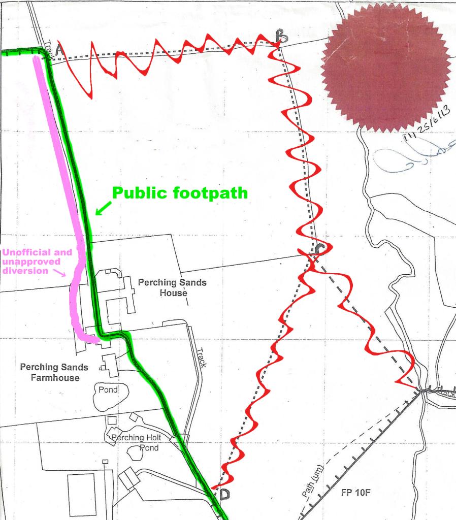
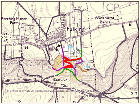
The DEFRA inspector charged with deciding whether Footpath 4f should be rerouted has ruled that it should not be. He concluded “that the adverse effect on the public’s enjoyment of the path if it were diverted in the manner proposed would be significant” and “the adverse effect on public enjoyment clearly outweighs the benefit .. to the landowners”. The proposed diversions (crossed out in red, above) will thus not come into force. Instead, the historic route (marked in green, above) retains its status as a lawful right of way. Here are some extracts from his report:
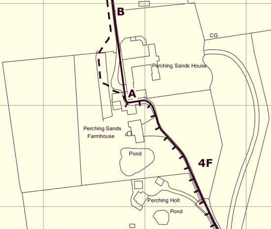
Footpath 4f runs .. almost immediately adjacent to the rear of Perching Sands House for around 40 metres. The public right of way runs past Perching Sands House in the way described, but that right of way has been unlawfully obstructed, and an unofficial path has been provided which passes some 10 metres to the west of the house.
The public right of way has been obstructed in the vicinity of Perching Sands House. For the purposes of assessing comparative convenience (and enjoyment) I take into account the lawful right of way, treating it as if it was open and available for use, and not the unofficial and unapproved diversion which has been created by the landowner.
From the northern end of the curtilage of Perching Sands House to point A the right of way (although not the path provided by the landowner which lies immediately to its west) runs along a track with a good hard surface which seems unlikely to be muddy in wet weather (the site visit was carried out during a prolonged dry spell). The Definitive Statement for the path does not list any stiles or gates as lawful limitations on the public’s use.
It is reasonably clear where the path runs (or should run), and the correct route could be emphasised by signage so that there was no danger of people inadvertently wandering off the public right of way.
The full report is here [PDF].