Not the most direct route
The community website of the village of Fulking, West Sussex

The terrain, vegetation, architecture and artefacts of the area described by reference to location.
The area between Amberley and Ditchling is what Americans call a ‘dry county’. That’s why pub-based South Downs walks are not possible in this benighted region. Or so The Telegraph would have you believe. [Confused Telegraph readers who find themselves on this page should look here.]
Our two earlier posts on the LiDAR-based archaeological research into what lurks within the wooded areas of the South Downs were in July 2013 and March 2014. The SDNPA is now calling for volunteers to (i) poke around in the woods [field surveys], (ii) poke around in dusty boxes in Chichester [archive research], or (iii) interrogate elderly locals [oral history]. More information here and at the WSCT.
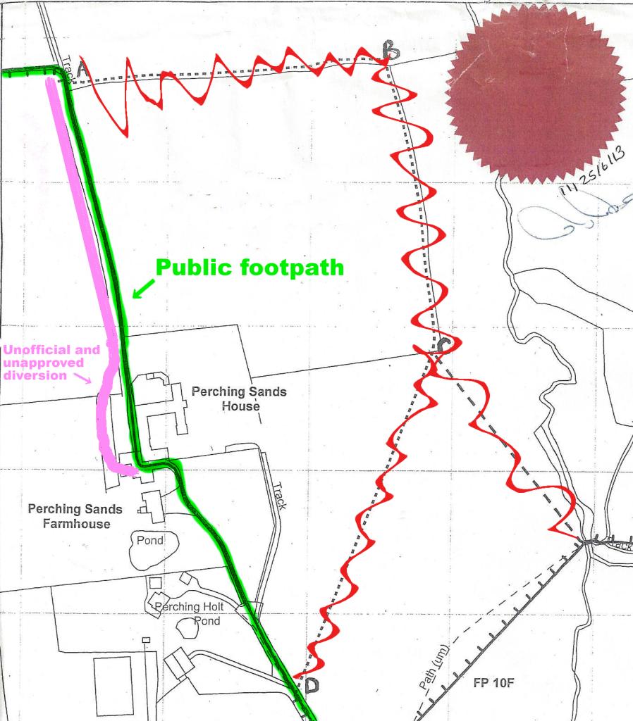
The DEFRA inspector charged with deciding whether Footpath 4f should be rerouted has ruled that it should not be. He concluded “that the adverse effect on the public’s enjoyment of the path if it were diverted in the manner proposed would be significant” and “the adverse effect on public enjoyment clearly outweighs the benefit .. to the landowners”. The proposed diversions (crossed out in red, above) will thus not come into force. Instead, the historic route (marked in green, above) retains its status as a lawful right of way. Here are some extracts from his report:
Footpath 4f runs .. almost immediately adjacent to the rear of Perching Sands House for around 40 metres. The public right of way runs past Perching Sands House in the way described, but that right of way has been unlawfully obstructed, and an unofficial path has been provided which passes some 10 metres to the west of the house.
The public right of way has been obstructed in the vicinity of Perching Sands House. For the purposes of assessing comparative convenience (and enjoyment) I take into account the lawful right of way, treating it as if it was open and available for use, and not the unofficial and unapproved diversion which has been created by the landowner.
From the northern end of the curtilage of Perching Sands House to point A the right of way (although not the path provided by the landowner which lies immediately to its west) runs along a track with a good hard surface which seems unlikely to be muddy in wet weather (the site visit was carried out during a prolonged dry spell). The Definitive Statement for the path does not list any stiles or gates as lawful limitations on the public’s use.
It is reasonably clear where the path runs (or should run), and the correct route could be emphasised by signage so that there was no danger of people inadvertently wandering off the public right of way.
The full report is here [PDF].

The Mineral Sites Study [PDF] is a recently published document deriving from the joint SDNPA/WSCC exercise known as the Minerals Local Plan. Despite four pages devoted to a potential seventy acre gravel pit on a greenfield site in Woodmancote*, there is little in it to interest a resident of Fulking or Edburton. The one possible exception is a five page section [PDF] devoted to Shoreham Cement Works. There’s a lot of chalk left, apparently, and a planning permission for further extraction that runs until 2042, a fact that appears to have come as an unwelcome surprise to the current generation of planners (as it may to future generations of the ‘rare breeding birds’ who have made the site their home). If you feel inclined to respond to the study, then WSCC provide a form here.
*Not our northern neighbour but a different village, located to the west of Chichester.
The Argus reports:
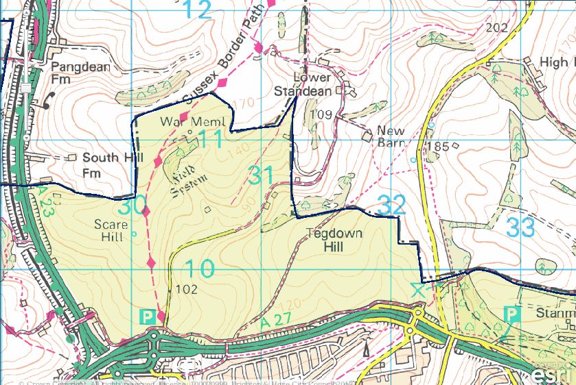
Brighton and Hove City Council has created free public access to another 670 acres of Sussex downland. .. Five miles of new footpaths and bridleways have been created, meaning walkers on the Sussex Border Path can divert on to a route keeping them further away from busy roads. Works have involved installing gates and cutting a new path up a steep bank at Braypool. .. The surrounding landscape includes ancient burial mounds on top of Tegdown Hill, lynchet terraces .. and the Chattri monument.
The Mid Sussex Times reports:
Mayfield has stated that Horsham District Council (HDC) ‘does not have a full and proper understanding of the full objectively assessed need of the Housing Market Area’. Concern was raised by Mayfield about HDC’s ‘compliance with the legal test for the Duty to Co-operate’. The report states: ‘There is no publicly available evidence base which shows how meaningful engagement has taken place with neighbouring authorities in a continuous fashion prior to submission of the report.’ In addition, Mayfield raises issues with HDC, claiming it has ‘failed to calculate housing requirements’, ‘failed to allocate sufficient housing land’, ‘failed to allocate sufficient employment land’ and ‘absence of an effective Environmental Capacity Assessment’.
Update: the West Sussex County Times also has a report [PDF].
Update 27th July: LAMBS now has a post up on their website. Their main illustration is a Mayfield sewage map [PDF].

Readers of the Yr Arolygiaeth Gynllunio report [PDF] cannot help but notice that the inspectors were much exercised by Tottington Mount. It is discussed or referenced on no fewer than 32 pages. By contrast, there isn’t a single reference to Truleigh Hill anywhere.
Tottington Mount lies between the Truleigh Hill Youth Hostel and Tottington Manor Farm. There is a public footpath opposite the farm that will take you up and across the mount. It is extremely steep for much of the route. Apart from the splendid view to the north, there’s not much to see. You will pass a long low earthwork as you near the summit. The mount itself just looks like canonical downland to an inexpert eye. As the map above indicates, the trench will bisect the mount.
Tottington Mount is a virgin patch of Downs that has never been ploughed. As a consequence, it hosts noteworthy plant species (page 57). The works area for the trench is to narrow from 30-40 metres to 20-30 metres as it cuts across the area (page 94). E.ON will be spending £330K on bog matting and other mitigation expenses on this small section of the trench (page 38). Some details of the mitigation plans, and the SDNPA’s scepticism about them, can be found on pages 57-58. The inspectors think that these mitigation efforts may well fail (page 41). The trench will skirt the Beeding Hill to Newtimber Hill SSSI (Site of Special Scientific Interest) with a margin of about 50 yards at Tottington Mount. Disturbance to the chalk grassland species living within the SSSI will be ‘negligible’, apparently. Indeed, these species are set to benefit significantly from all the environmental monitoring that will be happening at Tottington Mount as part of the mitigation exercise (pages 52-53). However, Adonis Blue caterpillars may not share this upbeat view — they risk losing their lunch (pages 67-68).
The earthwork is a Bronze Age cross dyke and is listed as an ancient monument. The trench will go right through it (click the map above to see the detail of this), something that English Heritage refers to as a “substantial harmful effect” (page 178). The good news is that archaeologists will be funded to root around in the rubble — “appropriate archaeological supervision” (page 179, pages 398-399) — and English Heritage felt able to rule that “the harm is necessary in order to deliver substantial public benefits that outweigh the harm” (page 178). In turn, the inspectors concluded that there will be “be no loss of significance of any designated or undesignated heritage asset” (page 182) notwithstanding the “risk of adverse effects upon heritage assets, including the Tottington Mount Scheduled Ancient Monument” (page 227).
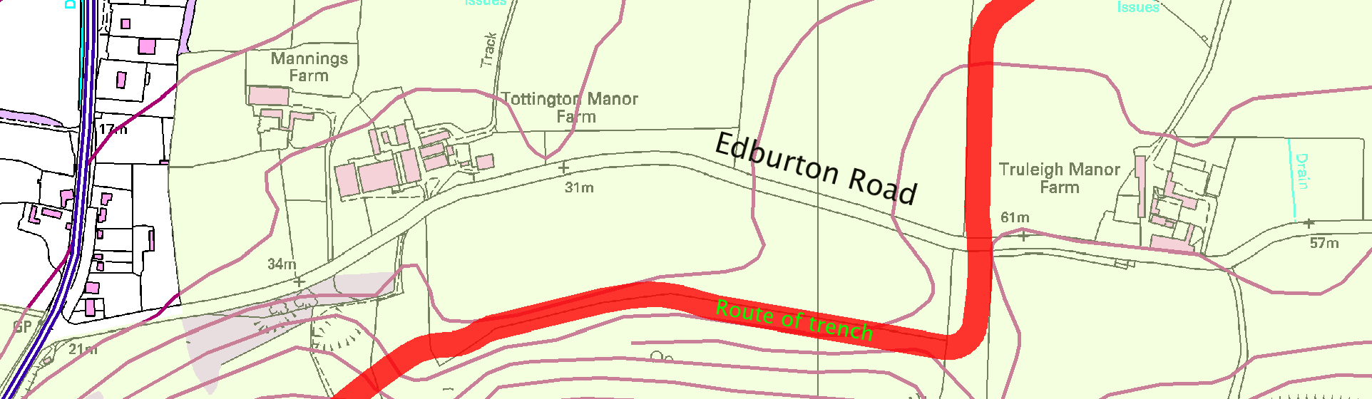
Local residents who still haven’t found time to read the report [PDF 5,900 pages] may be wondering what impact the trench is going to have on them. The answer, at least for those who live to the east of Truleigh Manor Farm, appears to be “not a lot”.
The main construction compound for the entire trench will be at the side of Edburton Road (page 153) and about 100m x 50m in size (page 159). The report itself does not show exactly where this compound will be located but it seems safe to assume that it will be very close to the point where the trench intersects the road (see above). Given the route that the trench will take, the main works traffic from this compound will use the A2037 rather than coming through Fulking and Poynings. There will be some temporary disruption to Horn Lane and to the A281 in Woodmancote when the trench is cut across them.