Edburton and Fulking in the 1922 Kelly’s Directory for Sussex

Title page of Kelly's Directory Sussex 1922

Title page of Kelly’s 1922 Directory for Sussex.

Frederic Festus Kelly was a senior Post Office official who purchased the rights to a London trade directory in 1835 and went on to become the most important 19th century publisher of commercial directories. A University of Leicester digital library project devoted to such directories observes that “Kelly’s success was based on the innovative content and formats of his publications. He championed the production of county and provincial directories covering all settlements in a given area. These provided a wealth of information about each place, often including a commercial, street and classified trades section. He also retained the title of Post Office Directory for some time, giving his publications an aura of officialdom.” There is an informative 1893 interview, “The Baedeker of Babylon” [PDF], with Kelly’s grandson about how the directories were compiled.

EDBURTON (anciently Eadburga’s Town) is a parish 4 miles east from Bramber Station on the Horsham and Shoreham section of the London, Brighton and South Coast railway, 10 north-west from Brighton and 53 from London, in the Horsham and Worthing division of the county, hundred of Atherington and Poynings, rape of Bramber, union and petty sessional division of Steyning, county court district of Brighton, and in the rural deanery of Hurst, archdeaconry of Lewes and diocese of Chichester.

The church of St. Andrew is of flint and stone, in the Early English style, and has a tower containing 3 bells: nine of the windows are stained: the font is of lead, and dates from 1180: the church was restored in 1878, at a cost of £1,573, and has 225 sittings. The register dates from the year 1559. The living is a rectory, net yearly value £320, with residence, in the gift of the Archbishop of Canterbury, and held since 1913 by the Rev. Edward Griffith Evans M.A. of Clare College, Cambridge, hon. O.F.

Lord Leconfield, who is lord of the manor, and the Crown are the principal landowners. The soil is green sand, clay and part gravel; subsoil, chalk and clay. The chief crops are wheat, barley, oats and potatoes. The area is 1,094 acres; rateable value, £735; population in 1911 was 114 in the civil and 302 in the ecclesiastical parish.

Letters through Small Dole. Upper Beeding is the nearest telegraph office. Poynings is the nearest money order office, 2 miles distant. Wall Letter Box near the church.

Public Elementary School (mixed), rebuilt in 1873, enlarged in 1883, for 75 children; Miss Averil Haigh, mistress.

  • J. Clayton J, M.I.O.E. Clappers Lane
  • Rev. Edward Griffith Evans M.A. (Hon. C.F.), Rectory
  • Henry Harris, farmer, Perching Manor
  • John Radcliffe Passmore, farmer, Edburton Farm
  • John Powell, market gardener
  • Walter Augustus Powell M.R.C.S., L.R.C.P.Lond. physician & surgeon
The Street, Fulking, c1910

The Street, Fulking, circa 1910.

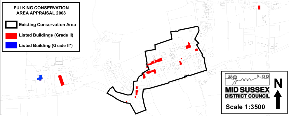
FULKING, Folking or Faulking (in Domesday Fochinges), in the ecclesiastical parish of Edburton, was constituted a separate civil parish under the “Local Government Act of 1894.” It is about 4 miles east from Bramber station on the Horsham and Shoreham section of the London, Brighton and South Coast railway and 8 north-west from Brighton, in the Lewes division of the county, Steyning union and petty sessional division and Brighton county court district. The Crown is lord of the manor. The soil is green sand, clay and part gravel; subsoil, chalk and clay. The chief crops are wheat, barley, oats and potatoes. The area is 1,552 acres; rateable value, £1,546; the population in 1911 was 188.

Post Office: Percival Lucas, sub-postmaster. Letters through Small Dole, Sussex. Poynings is the nearest money order office, 1 mile distant. Pyecombe is the nearest telegraph office, 3 miles distant.

  • Major Albert Adams, Old Farm House
  • Robert Atkins, The Croft
  • Mrs. Black
  • Charles E. Clayton, Holmbush Lodge
  • Laurence Clayton, Badger Wood
  • Samuel Payne, Fulking House
  • Duncan Sinclair, Hall Farm

COMMERCIAL

  • Mrs. Maria Baldey, Shepherd & Dog Public House
  • Thomas S. Hills, farmer and assistant overseer, Fulking Farm
  • Percival Lucas, grocer, Post Office
  • Arthur Pinker, farmer
  • Joseph Robinson, farmer, Perching Sands
  • Henry William Uridge, farmer

[All material transcribed, with minor formatting and punctuation changes, from pages 359, 360 and 373 of the 1922 edition of Kelly’s Directory for Sussex, published by Kelly’s Directories Ltd., London.]

GJMG

John Ruskin, the pump house, and the fountain

"John Ruskin in 1873 photographed by Frank Sutcliffe"

John Ruskin in 1873 photographed by Frank Sutcliffe

Artist, botanist, geologist, poet, polymath, proto-socialist, writer (39 volumes), and much else besides, John Ruskin (1819-1900) was a cultural colossus of Victorian England. He gave his first sermon when he was five years old and published his first journal article when he was fifteen. Today he is primarily remembered as the greatest art historian of his era. Residents of Fulking, however, have another reason to remember him — as a civil engineer: “He smiled a little at himself in later years when .. he said that civil engineering was his true bent and that his devotion to literature and art had all been a mistake, and that England had lost in him a second Telford.” [E.T. Cook (1912) The Life of John Ruskin, London: George Allen, Volume II, pages 163-164]

“The inhabitants of Fulking .. had for a long time a great difficulty in obtaining an adequate supply of drinking water. A hilly gathering ground was near, but nature seemed to have intended the water for other localities. All sorts of expedients were adopted, but all proved a failure. It happened that Ruskin occasionally visited the district, and the idea occurred to somebody that he might be able to help. The request was a strange one, but Ruskin began to think what could be done and, in the end, devised a scheme which has given Fulking as much water as it can ever hope to consume. Works have of course been required, but they did not cost very much, and they certainly do not disfigure the locality. The people have not been slow to show their gratitude for the boon thus conferred, and near the well which gives the inhabitants a constant service they have erected a beautiful marble memorial.” [Pall Mall Gazette, August 26, 1891, from the Manchester Examiner, reproduced in The Works of John Ruskin, London: George Allen, Volume 34, page 719. PDF]

"The pump house door, Fulking"

The pump house door

“John Ruskin .. had the idea of harnessing the waters of the Fulking stream to power an hydraulic ram which would pump the supply around the parish. The little Gothic pump house is still there and on it is a plaque bearing an inscription from Psalms 104, 10 and 107, 8.” [Brigid Chapman (1988) West Sussex Inns, Newbury: Countryside Books.]:

Inscription from Psalms displayed on the side of the Fulking pump house

Pump house inscription

“The various structures associated with the village’s ingenious nineteenth century water supply are a unique feature of Fulking. Around 1886, water from the spring (located close to the Shepherd and Dog Public House) was harnessed to provide the village with its own piped water supply. Two men are credited with devising and instigating this scheme. One was John Ruskin .. and the other was Henry Willett from Brighton. The system supplied the village with piped water until mains water eventually arrived in 1951. The arrangement consisted of an hydraulic ram driven by water from a brick lined reservoir/balancing tank (located in the garden of the Shepherd and Dog) pumping water up to a reservoir close to Old Thatch on the north side of The Street. Although no longer working, the system remains largely intact today.” [Ed Lancaster (2008) Fulking Conservation Area, Haywards Heath: MSDC, page 9. PDF]

Tony Brooks reports that Ruskin used to stay at The Old Bakehouse (next door to the Shepherd and Dog) and that the new water supply involved “four reservoirs: one under each of the hand pumps in The Street, one for the drinking fountain by the entrance to the North Town Field and one at Perching Manor. The villagers maintained the system and the last person known to have been in charge of it was the local builder, Charlie Franks, who lived in Fulking all his life”. [Anthony R. Brooks (2008) The Changing Times of Fulking and Edburton 1900 to 2007, Chichester: RPM, page 29.]

The key component of the Ruskin/Willett scheme was the hydraulic ram pump. It was invented by Joseph Michel Montgolfier in 1796 and modern versions are still in use today. Its key advantage is that it requires no external source of energy beyond that supplied by an existing water flow.

Easton and Amos ram pump, 1851

Easton and Amos ram pump, 1851

“The pumphouse by the roadside was part of the supply arrangements which continued until a new supply was provided in 1953. There is a small fountain in the village which [bears] the following inscription: ‘To the glory of God and in honour of John Ruskin Psalm LXXVIII that they might set their hope in God and not forget but keep his commandments who brought streams also out of the rock’.” [“A Ram Pump at Fulking”,Sussex Industrial Archaeology Society Newsletter 5, January 1975].

In honour of John Ruskin: inscription on the Fulking water fountain

The inscription on the Fulking water fountain

Ruskin’s water supply collaborator, Henry Willett, a wealthy local brewer, was responsible for erecting the fountain with its inscription. Ruskin, however, was less than enthusiastic, writing to Willett in June 1887, with “sincere thanks for your kind note .., but I am too sad and weary just now to see anything; and I was grieved by your inscription on the fountain, for it made my name far too conspicuous, nor did I feel that the slightest honour was owing to me in the matter” [The Works of John Ruskin, London: George Allen, Volume 37, page 591.].

GJMG

For more information on the local water supply, see Anthony R. Brooks (2008) The Changing Times of Fulking and Edburton 1900 to 2007, Chichester: RPM, pages 28-30. Interested readers may also wish to try and track down the following items: (i) Paul Dawson “John Ruskin, Fulking and the water supply”, Friends of Ruskin’s Brantwood Newsletter, Spring 1996; and (ii) Joyce Donoghue “Looking into Ruskin’s Sussex connection”, Friends of Ruskin’s Brantwood Newsletter, Spring 1995.

Currently popular local history posts:

Domesday Book entries for Fulking

“Domesday is our most famous and earliest surviving public record. It is a highly detailed survey and valuation of all the land held by the King and his chief tenants, along with all the resources that went with the land in late 11th century England. The survey was a massive enterprise, and the record of that survey, Domesday Book, was a remarkable achievement. There is nothing like it in England until the censuses of the 19th century.” [National Archives: Discover Domesday]

"Photograph of Great Domesday from the National Archives"

Each entry was intended to record, inter alia, the name of the manor; the identity of the owner(s) in 1066 and 1086; the tax assessment (‘hides’); the number of ploughing teams employed; the population of villagers, smallholders, slaves, etc.; the acreage of various types of land use; and the value of the manor and its components. Local readers will notice that there has been a certain amount of land and property price inflation since 1086 and that Edburton does not appear in the Domesday Book, either by that name or by its Saxon name, Abberton.

  • Lewes Rape XII.26: Leofnoth holds Pawthorne from William. He held it from King Edward; he could go wherever [he would]. Then it answered for 4 hides; now for 1.5 hides because the others are in the Rape of William of Braose. Land for 1 plough. It is there in lordship, with 2 smallholders. 3 sites in Lewes at 18d. The value is and was 30s.
  • Lewes Rape XII.27: Osward holds Perching from William. He held it before 1066; he could go where he would. Then and now it answered for 3 hides. Land for 2.5 ploughs. In lordship 1; 2 villages and 4 smallholders with 1 plough. 0.5 mill at 40d; meadow, 7 acres; woodland, 2 pigs; 1.5 sites in Lewes at 9d. The value is and was 40s.
  • Lewes Rape XII.28: In the same village Tesselin holds 2 hides from William. It answers for as much. It lay in (the lands of) Truleigh, which William of Braose holds. Belling held it from Earl Godwin. In lordship 1 plough; 3 villagers and 2 smallholders with 0.5 plough. 0.5 mill at 13s 4d; meadow, 3 acres; woodland 2 pigs; 0.5 site in Lewes at 2d.
  • Lewes Rape XII.29: Tesselin also holds Fulking from William. It lay in (the lands of) Shipley, which William of Braose holds. Harold held it before 1066. Then and now it answered for 3 hides and 1 virgate. 6 villagers with 2 ploughs. These two lands of Tesselin are together. The value is and always was 50s.
  • Lewes Rape XII.35: William of Watteville holds Perching. Azor held it from King Edward, and 2 men from Azor. Then and now it answered for 5.5 hides. Then there were 2 halls; now it is in 1 manor. Land for 5.5 ploughs. In lordship 1; 4 villagers and 3 smallholders with 1 plough. 2 slaves; meadow, 3 acres; woodland, 3 pigs; from asture 6d. Value before 1066, 60; later 40s; now 50s.
  • Lewes Rape XIII.6: William, a man-at-arms, holds Truleigh from William. Belling [held] it from Earl Godwin before 1066. Then it answered for 4 hides; now for nothing. Land for 2.5 ploughs, In lordship 1 plough; 3 villagers and 6 smallholders with 0.5 plough. 2 mills at 65d. Ansfrid holds 0.5 hide of this land. He has 0.5 plough. Value of the whole manor before 1066 4 pounds; later 60s; now 70s.
  • Lewes Rape XIII.7: William himself holds Tottington, in lordship. It lay in (the lands of) Findon. An outlier. Harold held it before 1066. Then it answered for 6 hides; now for 1 hide. Land for 5 ploughs. In lordship 1; 3 villagers and 7 smallholders with 2 ploughs. Meadow, 4 acres. One William holds 2 hides of this land. He has 3 villagers with 1.5 ploughs. Total value before 1066, leter and now 6 pounds.

[Extracts taken from John Morris’s 1976 edition and translation, Domesday Book. Chichester: Phillimore.]

These entries are translations of the heavily abbreviated Latin in which the original manuscript was written. Even if you did Latin at school, you will probably have a hard time making sense of this:

"Entry for the royal manor of Earley (Herlei), near Reading in Berskhire, catalogue reference E 31/2/1 f.57"

If you want to learn more about the Domesday Book, then both the National Archives and the BBC have excellent reference pages. If they whet your appetite for more then David Roffe, the UK’s foremost Domesday historian, has plenty of material available at his website. And if you decide that you simply must have a facsimile, then a range is available from Addison Publications.

GJMG

Fulking Conservation Area

Fulking Conservation Area Appraisal 2008
In November 2007, Mid Sussex District Council (MSDC) held a public meeting and an exhibition to illustrate the work that had been carried out on Fulking Conservation Area Appraisal over the proceeding months. The public meeting was held in the Village Hall, the Street, Fulking on Thursday 12th November 2007. The exhibition was held in Hurstpierpoint Library, Trinity Road, Hurstpierpoint from Monday 26th November until Friday 7th December. At the time, exhibition panels were also made available on the MSDC website.

Fulking Conservation Area Appraisal DocumentThe exhibition included a detailed assessment of the character of the conservation area, suggested a number of changes to the boundary and provided some potential ideas for enhancement. Questionnaires relating to the draft management proposals were made available at all of the locations listed above. The deadline for the receipt of comments was Friday 14th December 2007.

In May 2008, as a result of local consultations, the MSDC Planning Policy Division issued the Fulking Conservation Area Appraisal Document (PDF).

Another document (PDF) summarised the comments the Council received to the questionnaire and set out responses prepared by officers on behalf of the Council to the main issues raised. Wherever possible suggestions made by the public were included in the appraisal document.

The existing Fulking Conservation Area
It should be noted that, although MSDC agreed in principle to the extended conservation area, it has not been been legally adopted. Thus the original conservation area still stands.

Updated and corrected, 5th & 9th December 2013.