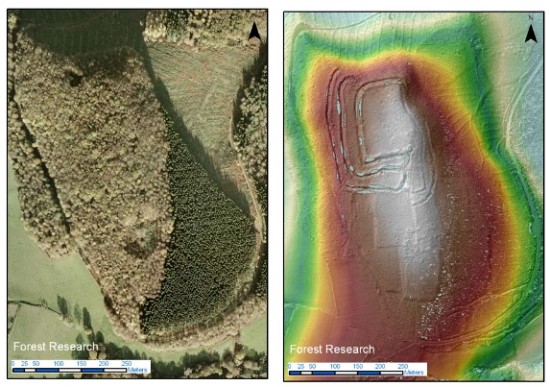
Residential continuity in the nineteenth century


If you wander around the churchyard at St. Andrew’s peering at graves, you will soon get the impression that certain families persisted in the parish over several generations. But many of the older graves are hard to read and some are missing altogether. To get a more accurate sense of how many residents had parents who also lived in the parish, we need to turn to the nineteenth century census returns. The first ‘modern’ census, in 1841, only asked respondents if they had been born in the county in which they were then living. But the 1851 and subsequent censuses asked for both the county and the parish of birth. These later censuses thus permit a rather fine-grained analysis of the relation between where people were living and where they were born.

Year EdFulk AdjPar ElsSus OutSus Total
1851 57% 14% 26% 3% 288
1861 41% 18% 34% 6% 299
1871 41% 11% 38% 10% 300
1881 41% 11% 39% 8% 340
1891 39% 9% 38% 14% 358

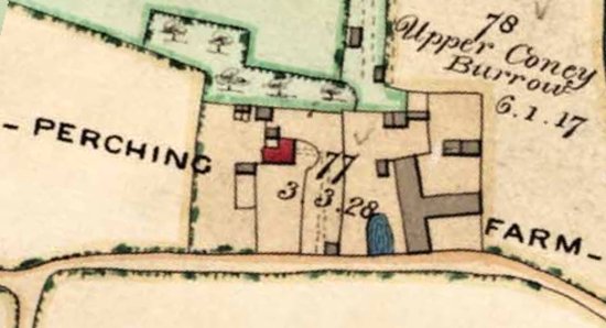
Where were the residents of the parish born?

In this table[1], the rows correspond to the five censuses that took place in the second half of the nineteenth century. The columns show the census year; the percentage of the parish population who were born in the parish (i.e., in Edburton or Fulking, EdFulk); the percentage who were born in one of the immediately adjacent parishes (AdjPar), i.e., Poynings, Portslade, [Old] Shoreham, [Upper] Beeding, Henfield or Woodmancote; the percentage who were born elsewhere in Sussex (ElsSus); the percentage who were born outside Sussex (OutSus); and the total size of the population in the census year.

The first row is perhaps the most striking. In 1851, over 70% of the residents of the parish were living within easy walking distance of where they were born (i.e., in Edburton or Fulking or one of the immediately adjacent parishes) and only 3% had been born outside Sussex. By the last decade of the century, the corresponding figures were 48% and 14%, respectively, and the size of the local population had increased by nearly 25%.

The remaining four rows are notable more for their similarity each with the next than for any radical changes. As the total population increases, the proportion of residents born in the parish remains more or less constant, as does the proportion born in Sussex but outside the immediate area (ElsSus). The proportion born in the immediately adjacent parishes halves over the 1861-1891 period whilst the proportion born outside Sussex more than doubles.

The first table provides a good sense of where the population had come from in any given census year but it does not give us a sense of the family structure of the parish. To get that, we need to look at the way the main resident families[2] persisted over time:

Family 1841 1851 1861 1871 1881 1891
Barber 22 13 13 14 3 0
Baird/Beard 3 4 4 3 12 15
Burtenshaw 15 5 11 10 10 6
Cousins/Cozens 4 2 10 11 3 1
Jackson 5 7 5 2 7 0
Lelliot/Lelliott 10 12 20 4 10 0
Madgwick 0 3 4 2 2 1
Marchant 10 11 1 4 2 3
Morley 8 8 7 8 16 9
Page 1 1 7 18 10 9
Paine/Payne 40 40 27 10 6 10
Pollard 5 6 2 6 8 5
Sayers 3 4 5 3 7 15
Steel/Steele 16 29 14 13 14 13
Stevens 7 11 10 11 13 7
Stoveld/Stovell 5 9 9 4 3 7
Strevens/Strivens 12 14 13 8 11 14
Willet/Willett 10 7 8 13 5 5

Families resident in the parish for five contiguous censuses

These eighteen (extended) families comprised nearly two thirds of the population of the parish in 1851. By 1891, that proportion had declined to one third. The overall picture is thus rather what one would have expected: over the course of the second half of the nineteenth century, the outside world gradually made its presence felt in what had hitherto been a somewhat isolated rural parish.

Footnotes

[1] A couple of rows sum to 99% rather than 100% as a consequence of rounding.

[2] Family members are defined here by surname, not genetics. If Jane Paine marries Bert Burtenshaw and remains in the parish then she will be counted as a Burtenshaw, not as a Paine, in the following census. Where the census takers used alternant spellings for a surname, both are listed in the table.

References

  • Marion Woolgar (1995) Census transcriptions and surname index for Edburton & Fulking. Published by the Sussex Family History Group.

GJMG

New South Downs Book Series

New South Downs National Park book series
UPDATE, 21st July: all three volumes are now available — my copies arrived a couple of days ago, GJMG.

There’s a new book series on the South Downs with volumes on the archaeology (John Manley), geology (David Robinson) and natural history (Robin Crane and Rendel Williams). The geology volume appears to be available now but note that there’s a slightly discounted price if you order all three volumes at the same time.

Mapping the woods

Aerial photo versus LiDAR showing hidden archaeological features

A regular aerial photo compared with a LiDAR image of the same area. The latter reveals archaeological features that are hidden in the former.

The BBC reports that:

Ann Bone, the authority’s cultural heritage expert, said laser technology on a plane would be used to produce a map of the landscape under the trees. Archaeological work on the ground would then follow .. Maps will be created of the most densely-wooded area from the River Arun to the A3 road. .. Data gathered by directing a laser at the ground and measuring the reflected light would provide a three-dimensional map showing all the “humps and bumps” under the forest.

The £935,756 project has received nearly £662,000 from the Heritage Lottery Fund and up to £130,000 from the park authority.

Update: the SDNPA press release.

The Masterplan

Map of Stanmer Park
A free concert in which a reformed 0asis perform their old B-sides in Stanmer Park? No, sorry. More like an exercise in which B&HCC attempts to get external funding for all those tasks that have been left undone since Brighton Corporation took the estate over back in 1947. However they are providing an excellent large-scale PDF map of the park which may prove useful next time you visit.

Fulking from the air in April 1946

Fulking from the air, April 19th, 1946

Fulking, April 19th, 1946: click the image to see it at the original size.

The University of Sussex has released a large archive of aerial photos of Sussex taken in 1946. You can view (and download) the full photo from which the above fragment was extracted and there is a slightly clunky interactive map that allows you to get at neighbouring images. You click on the green plane symbols to access the photos.

Perching Barn

Perching Farm as it was in 1842

Perching Farm as it was in 1842 — Perching Manor is the building shown in red, the duck pond is shown in blue and the farmyard is to the right. The large T-shaped building is Perching Barn with stables immediately due north and the grain store/cattle shed to the north east.

Until relatively recently, Perching Manor was a farmhouse and the area to its immediate east was the farmyard. There had been a farmyard in that location for hundreds of years. Farm buildings come and go, of course, but the largest building dates back to the eighteenth century. Houses have human residents who leave a history. We know quite a bit about the history of Perching Manor itself and even of the fortified building that preceded it and of the manor more generally. But farm buildings give rise to few records. The owls, rodents and feral cats who take up residence pass through anonymously, untroubled by police, lawyers, census takers and registrars of birth, death and marriage. Thus most of what is known about the history of this now former farmyard is of recent vintage — the last eighty years or so.

The largest, and most distinguished, component of the farmyard is Perching Barn. This is a Grade II listed eighteenth century building with weather-boarding on a flint base. The roof is slate, hipped at the north and half-hipped at the south. A large building today, the map shown above suggests that it was quite a bit larger still in the mid-nineteenth century.

Perching Barn was a fine example of a Sussex threshing barn. It had a wide entrance in the centre of the (long) side that faced west and was high enough to allow a threshing machine to be positioned and operated in the centre of the building. Sheaves of corn were loaded from both sides of the machine and the grain was then stored on either side of the building. Once threshed, the straw was ejected from the back of the thresher to the outside of the building. When not in use during harvest it was available for other uses — such as village barn dances and parties.

Perching Barn as it was in 1934

Perching Barn as it was in 1934 — the duck pond was much larger then than it had been in the mid-nineteenth century (or is today). In cold winters, it froze and was used for skating and ice hockey. The last time it froze hard enough to permit skating was in 1983. Part of the stable can be seen on the left behind the barn.

To the immediate north of the barn stood a stable for the farm horses. In later years, as tractors replaced horses, it was used as a storage shed and workshop. To the north east, there was a two-storey building, with cattle pens at ground level and a grain and cattle feed store above. Feed was delivered to the cattle as required, via a chute. Calf pens and a storage shed were situated at the south end of the building.

Some time during the 1930s or 1940s, a man known only as Martin lived in the lower half of a two-storey barn situated behind this building, on ground that fell away sharply towards the stream to the north east. It seems that he was ex-army and well educated, but chose to live there on an earthen floor, using old sacks as bedding. From time to time he became very ill and was moved to the workhouse at Chailey, but as soon as he recovered he would walk back to his simple home in Fulking. It is thought that his income was mainly from an army pension, but he supplemented this by chopping wood and doing odd jobs at Perching Manor for which Henry Harris is thought to have paid him 10 shillings a week.

George Greenfield was the local tramp. He may have been the George Greenfield who was born in Steyning around 1884. He lived rent-free in the ‘duck hut’, an open fronted, lean-to shed located at the southern edge of the farmyard. The shed had an open front and faced Perching Drove and the pond. George walked with a stick and had a dog. He was well known around the village and on most evenings could be found sitting in the same place at the Shepherd and Dog. He was known as the ‘threshing machine feeder man’ as this was his job when the contractor arrived in the district for the autumn/winter threshing period. In summer he did no work at all. Like Martin, his bedding was sacking and he hung sacks across the front of his hut to keep out the wind and rain. He cooked on a brazier and in winter he moved this inside the hut to provide heat. However, this meant that the hut filled with smoke, as there was only a small gap just below the roof for it to escape through. When he became ill, George was also taken to the workhouse at Chailey, but once recovered, he too always walked back to his shed, where he eventually died.

As farming became more mechanised, the barn was divided up. Half was used as a grain store, whilst the other half became a milking parlour and dairy. Later, Brian Harris, who was the farmer at the time, switched to arable production only. This decision was brought about partly because it was becoming impossible to find a cowman prepared to work the unsocial hours associated with livestock production and partly because of changes entailed by European Union farming policies. As a consequence, the barn became largely redundant.

Perching Barn in 1987 after the great storm

Perching Barn in 1987 after the great storm — the ducks may not have noticed, but the storm did serious damage to the barn.

In 1984 the Crown sold Perching Manor Farm to the National Freight Corporation. The latter sold it to Brian Harris in 1986. In the same year, Terry Willis, a developer trading as Sussex District Estates, came to Fulking and started buying redundant farm buildings for conversion to private dwellings. This was not straightforward as most had agricultural restrictions attached to them, but once these were lifted and planning permission had been obtained, the development programme began. In 1987, Brian Harris sold his redundant and derelict farm buildings to Willis. The sale included the barn, the stable and the grain store/cattle shed. Terry Willis, with the aid of an imaginative architect and some competent builders, converted these dilapidated buildings into attractive private residences during the 1990s (see the appendix below).

Perching Barn in 2007

Perching Barn in 2007 — to the left, Stable Cottage; to the right, The Granary.

Tony Brooks

[Copyright © 2013, Anthony R. Brooks. Adapted from Anthony R. Brooks (2008) The Changing Times of Fulking & Edburton. Chichester: RPM Print & Design, pages 182-185.]

Appendix

The 1990s Willis development process in pictures:

Perching Barn -- the skeleton

Perching Barn — the skeleton


The Granary

The building that was to become The Granary


Stable Cottage

The building that was to become Stable Cottage


Perching Barn

Perching Barn — the skeleton restored


The modern ground plan

The modern ground plan

Currently popular local history posts:

District Plan: Fulking

Fulking Draft Policies Map May 2013

Fulking Draft Policies Map May 2013 (click image to see full-size version)

Key:

  • DP9 — protection and enhancement of countryside (everything visible on the map except the core ‘built-up’ part of Fulking shown inside the thick black line).
  • DP15 — South Downs National Park (everything shown on the map).
  • DP33 — the Fulking conservation area (central pale yellow-green area plus green-blue area adjacent to the Shepherd & Dog).
  • DP36 — biodiversity/site of special scientific interest (pink, the north escarpment).

You will need to look at the District Plan (PDF) itself for the fine detail of what DP9, DP15, DP33 and DP36 imply for development, for example.

Bank Holiday Walks

Walking the Downs above Fulking
The May bank holiday looms and you face the problem of ensuring that your weekend visitors are kept both entertained and exhausted. Walks provide a tried and tested solution to this problem. Over this past winter, the Local Walks page (in the sidebar, under “About Our Village”) has been greatly expanded. There are links to over forty walks as well as a dozen or so walking maps available for download.

GJMG