Kent Cottage

Kent Cottage in the 1900s

Kent Cottage in the 1900s

An unsigned article in St. Andrews Quarterly for April 1950 is devoted to Kent House, as the building was then known:

A particularly fine specimen of half timbered architecture stands prominently at the entrance to the Village High Street of Fulking. Although some of the older inhabitants of the village recall its name as Kent Cottages, for there were originally two cottages but now joined into one, there seems to be no record of the change in the construction or its name.

The main part of the building dates from 1600 and one can easily detect the old portion as distinct from the more modern side — the lofty structure is raised over a basement, above which are two floors and is constructed entirely of timber framing in large braced panels.

Through the ages several interior alterations have been made, none of which have added to its original charm, although they have not destroyed the original structure.

Over the cellar remain the ‘Parlour’ with its outshut and large open fire-place with cambered and stop chamfered chimney beam, and a half bay on the other side of the chimney stack: in the sides of the chimney shaft still remain the large wrought iron hooks from which the huge joints of pork were hung to ‘smoke’. The beams on the first floor are all stop chamfered.

Little is known of this delightful old building and it would prove interesting reading if its history could be compiled: many of the inhabitants of Fulking have in fact lived in this house at one time or another and can recall earlier days when it was used as the Village Infirmary.

The building is far from being in good state of repair and we can only hope that it is not allowed to fall into decay

A drawing of Kent Cottage, date unknown

A drawing of Kent Cottage by W. Bothwell, date unknown

Writing a few years later, F.A. Howe adds some details about the construction of the building and confirms other aspects of the 1950 account:

In a commanding position at the entrance to the village from the east, on the south side, is Kent House, of about the year 1600. It is a lofty and imposing timber-framed building in large braced panels and consists of two storeys and an attic. The slope of the site is dealt with by the addition on the north side of a kind of undercroft. The south side of this chamber is a wall of the solid chalk along which rests an immense beam on which rests the interior timber framing of the floors above. Formerly it was known as Kent Cottages and was at that time two dwellings. Inhabitants now living say that their parents remember its being used as a poor law infirmary. [Howe 1958, page 32]

At some point during the last fifty years, the name of this Grade II listed building reverted to Kent Cottage, despite it being the tallest and one of the most striking houses in the village. It was once part of a two bay house and what we see today are the remaining one and a half bays of the original house. In the late 1800s and early 1900s, following the introduction of the Poor Law Amendment Act in 1834, it was used as a workhouse as well as an infirmary.

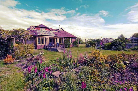
Many original features have been retained throughout the various changes documented above, including exposed beams and large open fireplaces in most rooms, even those in the attic. Consequently, a large chimney, some nine foot square, runs through the centre of the house to serve all these fireplaces. Along with this, a series of very steep, narrow staircases lead to the attic passing through the rooms on the upper floors, which greatly reduces the room sizes and gives the interior a quaint and unusual atmosphere. Over the years the external façade and historic character of the building has remained largely unchanged, apart from the addition of a conservatory tucked away on the south side of the building, which was added in 2003 and complements the interior of the house.

Kent Cottage in 2007

Kent Cottage in 2007

Tony Brooks

References

  • Unknown author (1950) “Kent House”, St. Andrews Quarterly 6, pages 13-14.
  • F.A. Howe (1958) A Chronicle of Edburton and Fulking in the County of Sussex. Crawley: Hubners Ltd.

[Copyright © 2012, Anthony R. Brooks. Adapted from Anthony R. Brooks (2008) The Changing Times of Fulking & Edburton. Chichester: RPM Print & Design, pages 161-162.]

Currently popular local history posts:

The Ladies’ Golf Course

Our Lady of the Green 1899

As you drive up the Devil’s Dyke Road, north of the bypass, you reach a point where you are less than half a mile from four different golf courses. That’s a lot. By contrast, the whole thirty mile stretch of Downs between Shoreham and Hampshire contains exactly as many, “two at Goodwood and two north of Worthing” (Bangs, page 159). For nearly fifty years, if you had followed the road a bit further, to the very top of the Downs, you would have come to yet another golf course. This one was immediately adjacent to, and to the south-west of, the Dyke Park Hotel. The associated club was an offshoot of the Brighton & Hove Golf Club [B&HGC] and membership was exclusively female: the Brighton & Hove Ladies’ Golf Club.

Ladies Golf Course 1905

A 1905 map of the Ladies Golf Course (from Hughes, page 62)

The course existed from 1891 to 1939. It was served by the Dyke Station, located to the south-east just off the map image shown above, over almost the entire period. It was thus very conveniently situated for members who lived in Brighton or Hove although it seems that most arrived “by pony and trap or by bicycle, or later on, by motor car” (Hughes, page 64). It had its own clubhouse and catering would also have been readily available at the Dyke Park Hotel.

As a consequence of WWI, the course closed for the period 1916-20 but members used the grounds and the clubhouse to entertain wounded soldiers. Play resumed in 1920 and the club began to attract younger players. The outbreak of WWII saw the final end of both club and course. The railway closed in December 1938 and the Ministry of Defence requisitioned much of the Downs. The clubhouse was completely demolished, possibly by Canadian tank crews. After the war, former members of the club had to fall back on their status as associate members of B&HGC if they wanted to play.

Miss Starkie-Bence 1892

Miss Starkie-Bence drives an ace to the North Town Field.

Well, probably not. But Miss A.M Starkie-Bence used to play on the course and she was a distinguished Sussex golfer active in the final decade of the nineteeth century, one who held numerous course records and medals. [The image derives from an 1892 issue of The Gentlewoman.]

Further reading:

  • Dave Bangs (2008) A Freedom to Roam Guide to the Brighton Downs. Portsmouth: Bishop Printers.
    [Pages 158-162 contain a rather comprehensive discussion of the many golf courses that have existed on the fringes of Brighton over the years.]

  • Barry Hughes (2000) Brighton & Hove Golf Club: A History to the Year 2000. Brighton: B&HGC.
    [Chapter 4, pages 62-67, contains the definitive history of the Ladies’ Golf Club.]

GJMG

With thanks to B&HGC for their assistance and for granting permission for the use of the map.

Amended 30th January, 2013.

Some other material relevant to the C19 and C20 history of the Dyke:

Customary Cottage

Customary Cottage in the 1900s

Customary Cottage in the 1900s


Customary Cottage, a Grade II Listed Building, is constructed in the traditional Sussex style of the 1600s, combining flint, brick and timber with a pitched roof, one which allows space for attic rooms. For many years, it was known as ‘Ivy Cottage’. The north gable end, which faces The Street, features ornamental black beams and what may be an owl window. It also had its own well near the back door. Although internally modernised to meet today’s standards of living, the low ceilings and exposed wooden beams remain attractive features of the cottage and the exterior remains largely unchanged.

Customary Cottage as seen from The Croft

Customary Cottage as seen from the garden of The Croft


Over the years the building has been used variously as a communal village washhouse, as a weekly surgery for a visiting doctor, and as the District Office for the Registrar and Relieving Officer. Relieving Officers were employed to receive applications for relief (the forerunner of today’s state benefits) and to make payments once the applications had been approved. At some point in the nineteenth century, it became a private house in the hands of the Beard family. Charles Baird/Beard (the spelling changes with the census date) was born in 1796 and a probable ancestor (John Berd/Beard) was living in Fulking in the first half of the 16th century. Charles Beard was living in Fulking with his family in 1841 (and quite possibly earlier) and worked as an agricultural labourer. He had a daughter, Sarah, who was working as a domestic servant at Knole House in 1861. He also had two sons, William and George. William followed his father into agricultural labouring and George became a carter. By 1881, William was living in Briar Cottage with his family, whilst his younger brother George was living at Perching Hill. By 1891, George had moved to Edburton Sands and William, whose family had expanded to include seven children, had moved to Customary Cottage. A 1949 issue of St. Andrews Quarterly notes that, over the previous 60 years, no fewer than 65 descendants of William and Ann Beard had “come within the peaceful atmosphere” of the cottage. During William’s time the house had become known as ‘Ivy Cottage’, for a then obvious reason. But the name has reverted to ‘Customary Cottage’ in more recent years. Subsequent to 1891, William had a second son, born in the cottage, who was named after his father. The younger William emigrated to Australia in 1909 but remained in contact with his place of birth, bringing his family over to visit in 1949 and 1955, and writing letters, verse and historical pieces for St. Andrews Quarterly during the 1949-1958 period.

Customary Cottage in 2007

Customary Cottage in 2007


Charles Gearing, a joiner and cabinet-maker who had served in WWI, was married to one of the younger William Beard’s many sisters and, in 1941, they took over Customary Cottage. Charles Gearing sustained a serious motorcycle accident in 1950 and remained in poor health until his death in 1952 at the age of 64. His widow sold Customary Cottage to the Saunders family and moved to Kent in 1957.

Tony Brooks

[Copyright © 2012, Anthony R. Brooks. Adapted from Anthony R. Brooks (2008) The Changing Times of Fulking & Edburton. Chichester: RPM Print & Design, page 165.]

Currently popular local history posts:

Dew Ponds

Donald Maxwell 1926 Sheep Drinking

An illustration by Donald Maxwell for Rudyard Kipling (1926) Sea and Sussex, London: Macmillan, page 15.

The National Park Authority reports that “there are approximately 300 dew ponds across the South Downs”. Of these, at least eighteen are within easy walking distance of Fulking. The closest is on Tenantry Down, immediately above the village. This post considers what these relics are, how they worked, and why they are there.

Rudyard Kipling 1902 Sussex

There’s no water on the top of the Downs. No streams, no springs, no lakes, and few naturally occurring ponds. The Downs are made of porous chalk rock. When it rains, the water drains straight through. Livestock need water to survive. In a world equipped with powered pumps, galvanized troughs, and tractors that can tow water tanks, the need is relatively easy to address. But efficient steam pumps only became available towards the end of the 18th century and tractors only at the end of the 19th century. In earlier centuries, the traditional way of creating a supply of potable water was by digging a well. But this solution is of very limited applicability on the Downs. The water table is a long, long way down. Excavating a deep well is difficult and dangerous — gas seeps into the shaft. And making use of it, once excavated, requires prodigious amounts of energy. Thus there are few wells to be found on the Downs. One that does exist is at Saddlescombe, which sits at a relatively low elevation of 410 feet (compare Devil’s Dyke at 680 feet). The well is 160 feet deep and, when it was in use, employed a donkey in a wheel to provide the energy needed to raise water.

Cross section of a typical dew pond

Cross section of a typical dew pond

For at least a millennium, dew ponds (also known as ‘mist ponds’, ‘fog ponds’, ‘cloud ponds’ and, somewhat unsurprisingly, ‘sheep ponds’) provided the solution to the water collection and storage problem on the Downs. We know that such ponds existed in Saxon times and it has been argued that their construction and use goes back much further. Dew ponds are shallow man-made circular ponds commonly lined with compacted (‘puddled’) clay or compacted chalk paste. Since the nineteenth century, concrete has also been used as a waterproof liner. Other components found at some ponds include straw, lime, chalk rubble, gravel and stones. In the nineteenth century and the early years of the twentieth century, specialist teams toured the Downs during the winter and spring months and built or restored dew ponds. It would take four men about a month to excavate and line a pond. Horses or oxen walking in a circle were used to compact the clay.

Harry Pool Slade 1877

The life of a dew pond has been estimated at 100-150 years. Sustained extremes of temperature, whether high or low, can lead to the compacted liner developing cracks. And the roots of reeds or rushes can burrow through it. In the absence of maintenance, the pond starts leaking, the water drains out, and it grasses over. If it is still required, then it must be dug out and relined. Depending on the construction, the hooves of livestock can damage the lining and thus one sometimes sees a pond that is entirely fenced off but which supplies a nearby drinking trough via a pipe (the pond on Tenantry Down appears to involve this arrangement). Typical dimensions include a diameter in the range 30-60 feet, a depth of 3-6 feet, and a capacity of 10,000 gallons. Precipitation, at over 36 inches per annum, is the source of the water in dew ponds on the Downs. Evaporation reduces that amount by about half. Scientific controversy over candidate sources of the water in dew ponds persisted into the 1930s. Nowadays the ostensible motive for the restoration of dew ponds (as at Foredown Road), or even their creation de novo (as at Waterhall Bottom), is an ecological one. It is intended that they provide a habitat for amphibious reptiles, dragonflies, and waterfowl.

Donald Maxwell 1932 Dew Pond

Frontispiece to Donald Maxwell (1932) A Detective in Sussex: Landscape Clues to the Riddles of the Past, London: Bodley Head.

Appendix: A gazetteer of dew ponds near Fulking.

For more information about dew ponds, see:

  • Alfred John Pugsley (1939) Dewponds in Fable and Fact, London: Country Life.
    [The best available book on the topic. It includes a critical survey of the earlier literature.]

  • Philip Heselton (1997) Mirrors of Magic: Evoking the Spirit of the Dewponds, Chieveley: Capall Bann, pages 34-72.
    [Whatever you make of the rest of the book, chapter 2 provides a reasonable substitute for Pugsley and may be slightly easier to get hold of. The geographical focus of the book is on the Yorkshire Wolds rather than the Downs.]

  • Martin Snow’s 2006 website dewponds.co.uk contains much material of interest.

  • Valerie Martin’s 2012 catalogue of the Findon dew ponds.

GJMG

Currently popular local history posts:

Dr. Moon at The Croft

Dr. William Moon

Dr. William Moon
[Image from Rutherfurd 1898, frontispiece]


William Moon (1818-1894) was the inventor in the mid-1840s of an embossed alphabet for the blind (known as ‘The Moon Alphabet’, ‘Moon type’, or simply ‘moon’). He and his two children devoted their lives to the development and promotion of this alphabet [Adelaide (1845-1914) in the UK, and Robert (1844-1914) in the USA]. William Moon was born near Tunbridge Wells and contracted scarlet fever as a child. This led to partial blindness which had become total by the age of 21. He spent his adult life living in Brighton, initially with his widowed mother and subsequently with his first wife, Mary, and second wife, Anna Maria. In his early years, he scraped a living by teaching other blind people to read by touch. In addition to publishing moon books, much of his later life was devoted to initiating and promoting local Home Teaching Societies, and their associated free lending libraries of embossed books, to bring literacy to the blind. During and after his lifetime such societies were set up in many parts of the world.

The Moon alphabet

The Moon alphabet

In France, Louis Braille (1809-1852) had invented the alphabet that bears his name as a blind teenager in 1824. It was inspired by a more complex French military system intended to allow soldiers to read in the dark. Although braille was eventually to become the standard alphabet for the blind throughout the world, at the time of Moon’s invention it was little known outside Paris and remained that way until after Braille’s death. In contrast to braille, Moon’s system is based on the standard alphabet. It comprises 14 symbols each with a clear bold outline used in various rotations. For many blind people, especially those who become blind late in life, people with a restricted sense of touch, and those with learning difficulties, moon is significantly easier to learn than the more abstract braille system. However, many people have also gained confidence from first learning moon and then moved on to learn braille. Compared to braille, moon had two main disadvantages: (i) texts written in moon were very bulky (the Bible required 4,000 pages spread over 58 volumes), and (ii) moon was laborious to write, even with mechanical assistance, whereas braille was relatively easy to produce. Despite these issues, moon was very successful in the nineteenth century. Moon remains in limited use to this day although the RNIB discontinued most of their moon products, courses and services in early 2012 [PDF]. However, the introduction of ‘dotty moon’ means that moon text can now be easily and cheaply produced using standard braille embossers coupled to a computer with the appropriate software. Such a system is currently in use at Linden Lodge School.

William Moon’s work led to various formal accolades during his lifetime, most notably the honorary LL.D. awarded by the University of Philadelphia in 1871 which gave him the title by which he is commonly known today. Something of Dr. Moon’s personality and method of operating is captured by the following anecdote taken from his unpublished autobiography:

At this point it is interesting to learn from Dr. Moon’s autobiography how he had approached the staggering problem of printing moon for the Chinese. He began by writing to the secretary of The British and Foreign Bible Society saying that he thought he could print some books for the blind in the Chinese language. The secretary replied “Do you not think it a great piece of presumption to suppose that you can do anything for the blind in China?”, “Not at all” said Dr. Moon “If I had I should not have written to you.” The secretary enquired what assistance he needed and was told, “Money and a Chinese dictionary,” Two days later he received a cheque for £25 and seven large quarto volumes of a Chinese dictionary and grammar. “To work I went” reads the autobiography “and studied the language and in short time was able to prepare a few texts of scripture in my simplified alphabet for the blind.” He was given the opportunity of meeting Mr. Hockee, a Chinese gentlemen, who helped him to prepare The Lord’s Prayer in the “Pekin Colloquial”. This was sent to the local missionary at Ningpoo, a Miss Alders. She liked it and ordered some portions of the Church liturgy and a chapter of St. Luke’s Gospel. This was immediately provided at the expense of a benevolent gentleman, Mr. Taylor, of Clapham Common.

[reported by Andrew R. Cooper, A short history of Dr. William Moon]

The Croft, Fulking, Dr. Moon's summer residence

The Croft, Fulking, Dr. Moon’s summer residence
[Image from Rutherfurd 1898, facing page 228]

The Croft was built in 1890 as a summer residence for the Moon family. It replaced an earlier house on the same site, one that is recorded on the 1842 Edburton tithe map. It is a substantial property and sits well back from the road.

Early in the autumn of 1892 [Dr. Moon] was attacked by an illness which turned out to be a slight paralytic stroke. He was at the time staying at his country residence, The Croft, which he had built at Fulking .. as soon as he was able to go about again, he earnestly begged to be allowed to tell the “good tidings” once more in the Mission House which adjoined his grounds; and it was thought that it would be a comfort to him if he were permitted occasionally to give some public addresses to the people of the village .. He spent the winter of 1892 in Brighton, returning to The Croft as soon as the weather would permit in 1893. In order that he might take exercise easily whenever he chose, his daughter caused a perfectly level walk to be constructed around the lawn. The path was provided with a handrail, and by placing his hand upon it he could walk alone and with safety. In this way his health seemed to be re-established .. Even so near the end as the summer of 1894, when he returned to Fulking, he eagerly listened to the reports constantly brought to him from Brighton by his daughter, on whom there had lain for some time the chief burden of the work.

[Rutherfurd 1898, pages 257-258]

Dr. Moon had built the Mission House around 1890 on land next to his house that had been given to the rector, Francis Gell, and his successors by John George Blaker of Brighton a couple of years earlier.

Adelaide Moon

Adelaide Moon
[Image from Rutherfurd 1898, facing page 42]

Adelaide played a major role in the success of moon. She helped to run the printing house at 104 Queens Road, Brighton that produced the many moon books that were sent out to libraries for the blind around the world. And it seems likely that she introduced the first moon typewriter in 1908. When she died in 1914, The Croft was left to Samuel Payne to live in for the rest of his natural life (he died in 1923). Members of the Payne family are recorded as living in Fulking from at least 1841 to the 1920s. And the relevant Kelly’s Directory has Samuel Payne living in Fulking House as of 1922.

The Croft later belonged to the Harris family who rented it out to Miss Atkins who was Clerk to the Parish Council (and also secretary of one or more other village organisations) and after that Edwin Harris lived there with his wife and family. Since the late 1970s it has changed hands several times until the present owners purchased it in 1997. A plaque to the right of the front door records the link to Dr. Moon.

The Croft in 2012, viewed from the field behind the house

The Croft in 2012, viewed from the field behind the house

Appendix: further images related to Dr. Moon, his alphabet, and The Croft.

For more information about Dr. Moon and moon, see:

[Post updated 9th November 2012.]

Tony Brooks

[Copyright © 2012, Anthony R. Brooks. Adapted from Anthony R. Brooks (2008) The Changing Times of Fulking & Edburton. Chichester: RPM Print & Design, pages 155-156.]

Currently popular local history posts:


The Clappers of Clappers Lane

Signage at the north end of Clappers Lane

Facilis descensus Averno .. sed revocare gradum superasque
evadere ad auras, hoc opus, hic labor est.


Nowadays the primary function of Clappers Lane, residents apart, is to act as a Bermuda Triangle for credulous users of satellite navigation devices. But, until the road to Poynings was built in the early 1800s, Clappers Lane provided the only public route into Fulking and Edburton from the north. So it is a matter of some interest to ascertain how this once significant thoroughfare came by its curious name. The answer lies in the streams that cross the lane.

Anthony Brooks tells us that:

Until the early 1900s Clappers Lane flooded in three places: by the entrance to Brook House, [at] a ford just north of Knole House and at the junction of Clappers and Holmbush Lanes. Today, the streams at these locations now run under the carriageway, but before that, on the west side of the ford near Knole House, there was a simple, raised footbridge constructed of boards placed length ways. [2008, page 62]

Bridge over stream that borders Boggy Lagg

The bridge over the stream just north of Knole House (looking south)


Clapper is an ancient local word for a bridge across a stream formed by laying a plank on piles of stones, or a similar raised footpath for pedestrians alongside an occasionally flooded lane. According to the English dialect dictionary, a correspondent of Notes and Queries wrote in 1880 that “we have here [at Edburton] a lane called Clappers, so named from its ‘clapper,’ i.e. a raised footpath at side, to keep foot-passengers out of the water”. John Rowe, Lord Bergavenny’s manorial steward in the early seventeenth century, tells us that there were clappers at Fridayesmead, Sandstrete and “in ffulkinge”. F. A. Howe equates the first with the field still marked as Great Fridays on the 1842 tithe map (see 130 on the map below); the second with one which “survive[d] unused” in his day (1958) over the northern branch of the local stream in Clappers Lane, previously known as Sands Lane; and the third with a spot “on the main road where the stream crosses under Stammers Hill near the sheepwash”. These arrangements were obviously of long standing, because one of these, or one in a parish close by, gave its name to John atte Clapere (‘John at the clapper’), recorded in a nearby hundred in 1332.

Bridge outside Brook House and Hillbrook

The bridge over the stream by the entrance to Brook House (looking north)


Anthony Brooks takes up the question of the word’s origin on page 62 of his book. He says that it arose from the fact that the planks were partly unsecured, and “clapped” when walked on. However, clappers in other parts of the country, especially Devon, were made of heavy stone slabs, so that cannot be the whole story; and it cannot be true as early speculators thought, that the word derives from clapboard, which the name of John in 1332 also proves. Clapper also meant ‘stepping stones’, according to the English dialect dictionary, so wood is clearly not a necessary component of the definition.

Extract from the 1842 tithe map of Edburton parish

The 1842 tithe map showing “Clappers house &c”


The first record of the property called Clappers is in the parish registers in 1652: the burial of “the wife of Thomas Smith of the Clappers” (Howe, page 20); and a house with that name shows up on the 1842 tithe map for the parish of Edburton (see 132 on the map above). Thanks to the 1841 census we even know who was living in Clappers at the time. Members of that family were still living in the parish in 1881. The property makes repeat appearances, in the same location*, on the Ordnance Survey maps of 1898, 1920, 1940-45, and 1962. The original house no longer stands but has been replaced by Brook House which is located in a different part of the property (Brooks 2008, page 83). As can be seen, the property borders the stream that runs along the southern edge of Boggy Lagg and crosses the lane just below Clappers Sands where Brookside stands today; and, as noted above, this was the location of a clapper that lasted into the twentieth century.

There are two plausible hypotheses as to how the property came by its name:

  1. It may have taken its name from being adjacent to a clapper (or between two of them, as it was at one time); in more recent times a clapper seems to have been indifferently called by a singular or plural term.
  2. The form of the name, possibly with a possessive –s, suggests that it might comes from the surname, and therefore only indirectly from the clapper(s). On this etymology, an individual associated with a property near a clapper would have become known by reference to the clapper (“John atte Clapere”), the property, in turn would have become known as Clapper’s and then Clappers.

Finally, the property would have given its name to the lane, previously known as Sands Lane, that ran alongside it.

Richard Coates


*The current Clappers House is not in this location. It is further north, at the summit of a hill and thus far from both streams and clappers. Anthony Brooks reports that it was built and named after 1961 (2008, page 80).

References

  • Anthony R. Brooks (2008) The changing times of Fulking and Edburton: 1900 to 2007. Chichester: RPM Print & Design.
  • F.A. Howe (1958) A chronicle of Edburton and Fulking in the County of Sussex. Crawley: Hubners Ltd.
  • John Rowe (1622-35) Rentals and custumals of Lord Bergavenny’s manors. MS. now in East Sussex Record Office. Edited for publication by Walter H. Godfrey (1928) as The book of John Rowe, steward of the manors of Lord Bergavenny, 1597-1622. Lewes: Sussex Record Society (vol. 34).
  • Joseph Wright (1898-1905) English dialect dictionary. Oxford: Oxford University Press

With thanks to Nigel Vincent for the quotation from Vergil and to the local history editor for his help with research assistance and access to local material.

Copyright © Richard Coates, 2012

Currently popular local history posts:

Fulking Farmhouse

Fulking Farmhouse in the 1900s

Fulking Farmhouse in the 1900s (note false façade)


Fulking Farmhouse was built around 1650 and, as its name suggests, was originally a substantial farm property, one with several associated barns. It is of timber frame construction. The timber frame was concealed by a false façade in the 18th century, and this façade was only removed in the late 1930s.

Fulking records between 1910 and 1934 show that Thomas Hills was a tenant until an auction in 1934. At that auction the house was bought by Thomas (Tommy) Walton who had built up a chain of grocer’s shops in Hove and Brighton. He also purchased the adjoining fields which extended north, along the west side of Clappers Lane as far as Brook House and west to the stream that runs from the Shepherd and Dog. The farm became known as Walton’s Farm. Tommy’s sister Eileen lived there, whilst Tommy himself lived at Greenacres in Poynings.

Fulking Farmhouse and barn in the 1900s

Fulking Farmhouse (right of picture) and barn in the 1900s


During World War II, Henry Harris cultivated the farm under the terms of the wartime agricultural policy. In 1950, the Waltons sold the land, farmhouse and farm buildings to Harris. And he, in turn, later sold most of the farmland and all the buildings to Jack Cook who owned a well respected building company in Hove. While Jack lived in Fulking, he was instrumental in bringing about a number of changes along The Street. Several of the old barns had already been taken down by the early 1950s and the removal of one of Jack’s barns meant that the road could be widened to accommodate the increasing number of larger cars, vans and lorries that were now passing through Fulking. It was also at about this time that he built three new houses in The Street. And, in 1953/4, he donated the land and materials for construction of the village bus shelter.

Jack Cook later sold the house and he and his family moved to Shaves Wood Lane in Albourne. Since that sale Fulking Farmhouse has passed through several hands. In 1987 the house was purchased by a family who, over the ensuing twenty years, restored many of its original interior features and carefully preserved much of the house’s character.

Fulking Farmhouse in 2012

Fulking Farmhouse in 2012


Tony Brooks

[Copyright © 2012, Anthony R. Brooks. Adapted from Anthony R. Brooks (2008) The Changing Times of Fulking & Edburton. Chichester: RPM Print & Design, pages 153-154.]

The Hills at Pippins 1922-2011

Pippins in 2007

Pippins in 2007

Pippins stands on land that previously comprised two adjoining plots: Kent Field, described as arable and orchard; and Lower Kents, described as pasture, orchards and buildings. Both lots were purchased by Thomas Hills in a 1922 auction for £200 and £160 respectively. At the same time, he also purchased three adjacent cottages: Arcadia (for £215) and Yew Tree and Clematis Cottages (for £260). The entire holding extended north from the Poynings Road to Clappers Lane and included all the land as far as the boundary of Market Garden to the east.

Thomas Hills cleared and cultivated the land. In 1934, he started to build the bungalow. It was originally called ‘The Bungalow’ rather than ‘Pippins’. When he died in 1935, his youngest son Francis continued to work the land as a market garden with help from his wife Florence (known as Flo). They sold their produce through the wholesale fruit and vegetable market in Brighton (see photo below) and later, as the wholesale market became less reliable, from the back door of the bungalow.

Brighton Municipal Market, Circus Street, built in 1937

Francis Hills was a committed churchgoer. In his younger days he had cycled to Henfield every Sunday to attend services. He was also a stickler for traditional growing methods and loved work for work’s sake. He preferred to dig and hoe his 3+ acres by hand rather than use a plough or any other equipment because it helped to pass the time and keep him fit. The story goes that one cold winter’s day, when a bitter east wind was blowing, a newcomer to the village saw him digging and said, “You shouldn’t be doing that at your age, you will make yourself ill. Why are you doing it?” Francis replied, “Because! I don’t know any other way to stay alive!” He died in 1981, just a fortnight short of his 91st birthday.

In later years, Francis’s son Richard helped his parents with the market garden. As an extension to the back door sales, Richard also established a round in Brighton on two days a week, selling fruit and vegetables. After his mother died in 1977, Richard married Susan (Sue) in 1978 and moved to a greengrocer’s shop in Worthing. On the death of his father, Richard and Sue moved back to Fulking. By this time the market garden was no longer an economically viable business due to its small size and the increasing competition from rapidly expanding supermarkets. Richard then set up in business as a contract gardener and also started work in a local vineyard. Richard and Sue sold up and left Fulking for Hove in 2011.

Pippins, Poynings Road, Fulking

An advertorial for Pippins in the local press when it was on the market in 2011

Tony Brooks

[Copyright © 2012, Anthony R. Brooks. Adapted from Anthony R. Brooks (2008) The Changing Times of Fulking & Edburton. Chichester: RPM Print & Design, pages 145-146.]

Pippins Poynings Road Fulking

Pippins in 2015

History of Local Names

Common Hawthorn (Crataegus monogyna)

Common Hawthorn (Crataegus monogyna)


Paythorne

The oldest surviving spellings all suggest that Paythorne is named from a thorn-tree (hawthorn) associated with a Saxon man named Paga. This should have come to be pronounced “Pawthorn”, and documentary records right through to the 19th century prove that that is what happened. The alternative and current name is suggested by the Peathorne found in 1830, if the ea is as in steak, and it has not been explained. It may have been due to someone’s knowledge of the place called Paythorne on the Yorkshire-Lancashire boundary near Gisburn.

Pauethornam (Latin) in late 11th cent., Pagethorne in 1288, Pawthorne in 1633

Fulking

Fulking is an Anglo-Saxon name in –ingas, like Hastings, originally a name for a group of people but applied to a place (rather like Sussex ‘the South Saxons’). At Fulking, they were people associated with a man named Folc or Folca whose name meant ‘folk, people’, who is unknown to history. This name is not recorded by itself, but it occurs as the first element of names like Folcbeorht and Folcwine, and in Norman names like Fulk(e) which spring from the continental relative of the same element. In Hastings, the –s of –ingas has been retained, but in Fulking it has disappeared, and that is in fact what usually happens. Historians used to talk about the men whose names appear in place-names like this as tribal leaders or founding fathers of families, but we actually have no idea what relation the person bore to the group: father, godfather, hereditary or chosen leader on the basis of military or agricultural prowess, entrepreneur, slave-owner, or whatever: hence the vague “associated with”.

Fochinges in 1086, Folkinges in about 1091 and in 1260, Folkyngge in 1244, Fulkyng in 1327

Perching

Perching is a very difficult name whose origin is not known for certain. It seems to be an –ingas name like Fulking, but there is no known Anglo-Saxon personal name to suit the first part. If one were really clutching at straws, one might see a survival of the Roman name Poricus seen in that of the statesman Marcus Poricus Cato and members of his clan, which would reach the required form through known sound-changes in British Celtic and Old English. It may be an unrecorded Old English *perec (pronounced “PERRetch”) which could be an ancient English borrowing of Latin parochia ‘parish’, though there is no obvious reason for that. It might represent a variant *perric of the word pearroc, the source of park and paddock (and possibly itself derived from parochia), though what ‘people of the paddock’ might imply is equally obscure. It might not be an –ingas name at all, but a plural of a derivative of this word, *perricingas ‘the railed or fenced areas’. In this respect, it is interesting but probably misleading that in medieval times land was held of Perching manor for the service of fencing Earl Warenne’s deerpark in Ditchling.

Berchinges, Pʼcinges in 1086, Percinges generally in early Middle Ages, Perchinges in 1327

Close-up of part of a brass wall plaque in St. Andrew's, Edburton

Close-up of part of a brass wall plaque in St. Andrew’s, Edburton


Truleigh

Truleigh was until recently pronounced “true lie”, with the stress on the second syllable, a curiosity of Sussex, mainly Wealden, names containing Old English lēah ‘wood, clearing’ which dates back some 500 years. It has been claimed that the first element is trēo(w) ‘tree’, the whole meaning ‘clearing marked by a tree or trees left standing’. That is not linguistically impossible, but it seems much more likely to contain Old English trēow or trūwa, meaning ‘truce’, with reference to unknown historical events. Its position less than a mile from the boundary separating historic West and East Sussex (Bramber and Lewes rapes) may be relevant.

Truleg’ in the 13th cent., Treweli in 1261, Treule in 1281 (Trailgi in 1086 is misleading)

Edburton

Edburton is the farm or village of a woman named Ēadburg ‘wealth fortress’, whose identity is unknown. She is more likely to have been an overlord than an actual farming tenant or free peasant, but we cannot be sure. There were many prominent Anglo-Saxon women with this name. Since at least the 13th century the village was known as Abberton, and this pronunciation is retained in the name of Aburton Farm, the manor farmhouse.

Eadburgeton in the 12th cent., Adburghton in 1261, Ebberton in 1357, Abberton in 1377, Aberton alias Edberton in 1584

Tottington

Names formed with Old English -ingtūn are usually interpreted as ‘farm or village associated with a person called X’, and they are believed to date from a later period in settlement history than the –ingas type. X in this case is generally thought to be Totta, not a recorded Anglo-Saxon male name but occurring in enough Sussex place-names to make it a reasonable supposition. On the other hand, Tottington is sited just under a spur of the South Downs from which there is a spectacularly wide view over the Weald, Bramber and the opening of the Adur valley, which leads to the suspicion, supported by early spellings, that it is really Tōting-tūn ‘farm at the toot or lookout point’.

Totintune in 1086, Totington in 1291, Totyngton in 1294

Alternate spellings of the local names

In 1855 there were still alternate spellings of local names.

Richard Coates

References

  • Richard Coates (1980) A phonological problem in Sussex place-names. Beiträge zur Namenforschung, new series 15, 299-318. [On the stress problem illustrated in Truleigh.]

  • Allen Mawer & F.M. Stenton (1929-30) The place-names of Sussex. Cambridge: CUP (for the English Place-Name Society, Survey volumes 6 and 7). [Standard county work.]

  • L.F. Salzman, ed. (1940) [Victoria] history of the county of Sussex, vol. 7: Rape of Lewes. Oxford: OUP. [Standard county work.]

Copyright © Richard Coates, 2012

The Old Farmhouse

The Old Farmhouse, Fulking, in the 1900s

The Old Farmhouse, Fulking, in the 1900s


The Old Farmhouse is the only stone-faced building in Fulking and is believed to have been the original manor house. This property and Septima Cottages are probably the oldest buildings in the village. It is thought that the original building dates back to the 12th century and the mullioned windows and the east wall are 16th century. At one time a great hall extended north at the back of the house and a portion of the wall of this room remains part of the rear garden wall. The building has massive oak beams and one of the bedrooms has a floor of adzed oak planks, polished to a beautiful patina by many years of use. Up to 1930 the roof was finished with Horsham stone and until 1939 it had three staircases, but now has just two.

In the 1980s an elderly lady and broadcaster of Sussex history came to Fulking and gave a talk describing how she used to come to the village via the Dyke Railway just before war was declared in 1939. She lived with her aunt in The Old Farmhouse at one time and was able to show the present owner of the property where the third staircase had been located.

Stories associated with The Old Farmhouse abound. Smugglers are said to have used a hatch in the roof to pass kegs of brandy through to the shop next door. There is also supposed to be one, or possibly more, secret passages within the building. It has been suggested that one of these led to St Andrew’s Church in Edburton, but given the distance involved, this seems unlikely. Another theory is that the house was connected to the Shepherd and Dog for smuggling purposes, but so far, no evidence of the existence of either of these secret passages has been discovered.

King Charles II, disguised as a servant, en route to France

King Charles II, disguised as a servant, en route to France

There is a small room where, in 1651, King Charles II is said to have hidden, before escaping over the Downs, via the bostal, to Shoreham harbour, from where he left for exile in France and it is thought that the house was also used as a refuge by folk able to leave London during the Great Plague in 1665, which also occurred during the reign of Charles II.

Yet another tale describes how, in 1940, a very attractive young lady and equally attractive young man stayed at the house. They were a very quiet couple who kept themselves to themselves and never socialised or talked to any of the villagers. It seems that subsequently they just disappeared and were never seen again. It was only much later that it was discovered that they had been arrested as spies.

Of course, the house is reputed to have a ghost. It seems that she takes the form of a charming, little, old lady, dressed in white who carries a bible. Apparently, she makes herself known mainly to children, but during WWII she was seen by seventeen Canadian soldiers who were billeted there in late 1943. These men went on to serve in the Italian campaign and during that time they wrote to friends in Fulking, telling how the old lady was always with them when ever they went into action and not one of them was wounded.

Poster for the 1940 film "Gaslight"

Poster for the 1940 film Gaslight

From the 1920s to the 1950s the house was used as a tearoom and a large white teapot was painted on the roof to attract customers, particularly walkers, who could see it quite clearly from the Downs. Between 1920 and 1939 this was run by Miss Dolly Coles and during this time her customers included the writers H.V. Morton, Ernest Raymond and Jeffrey Farnol. It was reputedly in these tearooms that a conversation on the merits of oil lamps versus electric lights took place (possibly around 1935 when electricity first came to Fulking), giving Patrick Hamilton the idea for his 1938 play Gas Light which was later made into two films (British 1940, American 1944). The tearooms reopened after the war and eventually closed in the 1950s.

Tony Brooks

[Copyright © 2012, Anthony R. Brooks. Adapted from Anthony R. Brooks (2008) The Changing Times of Fulking & Edburton. Chichester: RPM Print & Design, pages 156-158.]